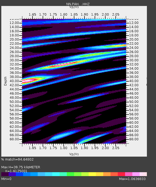
PAH Pah Rah Range, Nevada w84gm - Earthquake Result Viewer

Earthquake location: Near Coast Of Chiapas, Mexico
Earthquake latitude/longitude: 14.6/-92.1
Earthquake time(UTC): 2013/09/07 (250) 00:13:29 GMT
Earthquake Depth: 66 km
Earthquake Magnitude: 6.4 MWW, 6.4 MWB, 6.4 MWC, 6.4 MWW, 6.5 MWC
Earthquake Catalog/Contributor: NEIC PDE/NEIC COMCAT
Network: NN Western Great Basin/Eastern Sierra Nevada
Station: PAH Pah Rah Range, Nevada w84gm
Lat/Lon: 39.71 N/119.39 W
Elevation: 1520 m
Distance: 34.6 deg
Az: 321.5 deg
Baz: 128.623 deg
Ray Param: 0.07748303
Estimated Moho Depth: 39.75 km
Estimated Crust Vp/Vs: 1.61
Assumed Crust Vp: 6.279 km/s
Estimated Crust Vs: 3.894 km/s
Estimated Crust Poisson's Ratio: 0.19
Radial Match: 94.64802 %
Radial Bump: 371
Transverse Match: 83.48779 %
Transverse Bump: 400
SOD ConfigId: 626651
Insert Time: 2014-04-18 14:59:54.010 +0000
GWidth: 2.5
Max Bumps: 400
Tol: 0.001

Signal To Noise

ChannelStoNSTALTA
NN:PAH: :HHZ:20130907T00:19:41.774987Z4.86995273.0508394E-76.264619E-8
NN:PAH: :HHN:20130907T00:19:41.774987Z2.62363051.7517445E-76.676796E-8
NN:PAH: :HHE:20130907T00:19:41.774987Z1.05975161.0835505E-71.0224571E-7
Arrivals
Ps4.2 SECOND
PpPs15 SECOND
PsPs/PpSs19 SECOND