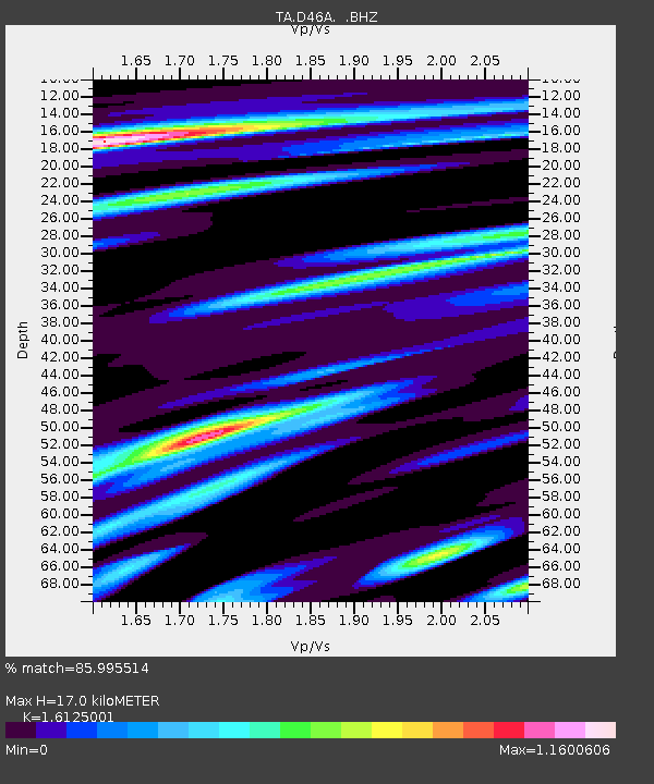
D46A Sault St. Marie, ON, CAN - Earthquake Result Viewer
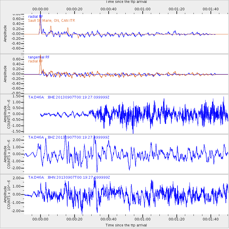
Earthquake location: Near Coast Of Chiapas, Mexico
Earthquake latitude/longitude: 14.6/-92.1
Earthquake time(UTC): 2013/09/07 (250) 00:13:29 GMT
Earthquake Depth: 66 km
Earthquake Magnitude: 6.4 MWW, 6.4 MWB, 6.4 MWC, 6.4 MWW, 6.5 MWC
Earthquake Catalog/Contributor: NEIC PDE/NEIC COMCAT
Network: TA USArray Transportable Network (new EarthScope stations)
Station: D46A Sault St. Marie, ON, CAN
Lat/Lon: 46.89 N/84.04 W
Elevation: 353 m
Distance: 32.9 deg
Az: 10.232 deg
Baz: 194.521 deg
Ray Param: 0.0782953
Estimated Moho Depth: 17.0 km
Estimated Crust Vp/Vs: 1.61
Assumed Crust Vp: 6.467 km/s
Estimated Crust Vs: 4.01 km/s
Estimated Crust Poisson's Ratio: 0.19
Radial Match: 85.995514 %
Radial Bump: 400
Transverse Match: 63.823082 %
Transverse Bump: 400
SOD ConfigId: 626651
Insert Time: 2014-04-18 15:03:27.996 +0000
GWidth: 2.5
Max Bumps: 400
Tol: 0.001

Signal To Noise

ChannelStoNSTALTA
TA:D46A: :BHZ:20130907T00:19:27.099999Z7.5896661.009533E-61.3301415E-7
TA:D46A: :BHN:20130907T00:19:27.099999Z5.10556945.703627E-71.1171383E-7
TA:D46A: :BHE:20130907T00:19:27.099999Z2.26800322.4240444E-71.06880115E-7
Arrivals
Ps1.8 SECOND
PpPs6.3 SECOND
PsPs/PpSs8.0 SECOND