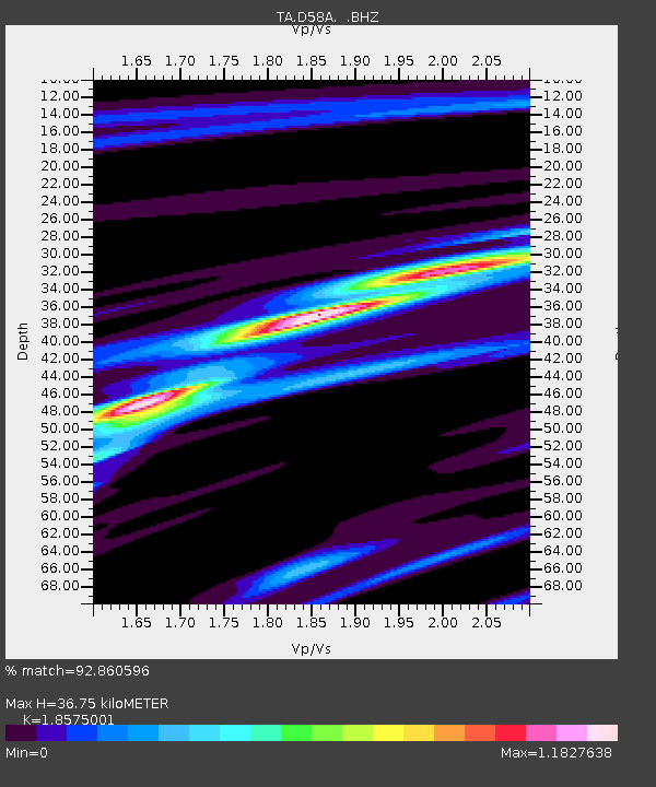
D58A Chemin du LacGrosbois, Trois-Rives, QC, CAN - Earthquake Result Viewer
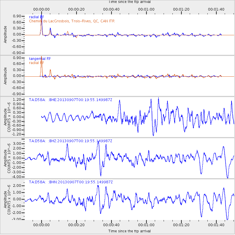
Earthquake location: Near Coast Of Chiapas, Mexico
Earthquake latitude/longitude: 14.6/-92.1
Earthquake time(UTC): 2013/09/07 (250) 00:13:29 GMT
Earthquake Depth: 66 km
Earthquake Magnitude: 6.4 MWW, 6.4 MWB, 6.4 MWC, 6.4 MWW, 6.5 MWC
Earthquake Catalog/Contributor: NEIC PDE/NEIC COMCAT
Network: TA USArray Transportable Network (new EarthScope stations)
Station: D58A Chemin du LacGrosbois, Trois-Rives, QC, CAN
Lat/Lon: 47.10 N/72.88 W
Elevation: 398 m
Distance: 36.2 deg
Az: 22.434 deg
Baz: 212.734 deg
Ray Param: 0.076648824
Estimated Moho Depth: 36.75 km
Estimated Crust Vp/Vs: 1.86
Assumed Crust Vp: 6.61 km/s
Estimated Crust Vs: 3.559 km/s
Estimated Crust Poisson's Ratio: 0.30
Radial Match: 92.860596 %
Radial Bump: 252
Transverse Match: 62.63166 %
Transverse Bump: 400
SOD ConfigId: 626651
Insert Time: 2014-04-18 15:03:59.630 +0000
GWidth: 2.5
Max Bumps: 400
Tol: 0.001

Signal To Noise

ChannelStoNSTALTA
TA:D58A: :BHZ:20130907T00:19:55.149987Z2.17695437.182013E-73.2991105E-7
TA:D58A: :BHN:20130907T00:19:55.149987Z1.97586734.5477174E-72.301631E-7
TA:D58A: :BHE:20130907T00:19:55.149987Z1.02226871.7395566E-71.7016627E-7
Arrivals
Ps5.1 SECOND
PpPs15 SECOND
PsPs/PpSs20 SECOND