E44A Grand Marais Airport, Grand Marais, MI, USA - Earthquake Result Viewer
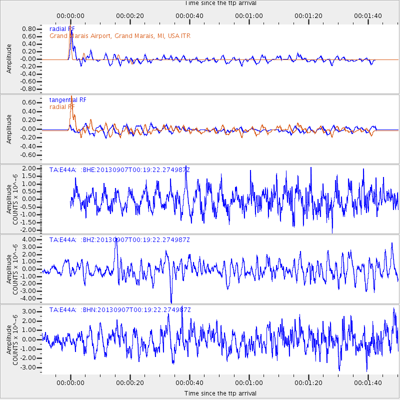
Earthquake location: Near Coast Of Chiapas, Mexico
Earthquake latitude/longitude: 14.6/-92.1
Earthquake time(UTC): 2013/09/07 (250) 00:13:29 GMT
Earthquake Depth: 66 km
Earthquake Magnitude: 6.4 MWW, 6.4 MWB, 6.4 MWC, 6.4 MWW, 6.5 MWC
Earthquake Catalog/Contributor: NEIC PDE/NEIC COMCAT
Network: TA USArray Transportable Network (new EarthScope stations)
Station: E44A Grand Marais Airport, Grand Marais, MI, USA
Lat/Lon: 46.62 N/85.92 W
Elevation: 282 m
Distance: 32.3 deg
Az: 7.999 deg
Baz: 191.271 deg
Ray Param: 0.07854227
Estimated Moho Depth: 50.25 km
Estimated Crust Vp/Vs: 1.82
Assumed Crust Vp: 6.467 km/s
Estimated Crust Vs: 3.558 km/s
Estimated Crust Poisson's Ratio: 0.28
Radial Match: 80.976135 %
Radial Bump: 395
Transverse Match: 58.53466 %
Transverse Bump: 400
SOD ConfigId: 626651
Insert Time: 2014-04-18 15:04:21.191 +0000
GWidth: 2.5
Max Bumps: 400
Tol: 0.001

Signal To Noise

ChannelStoNSTALTA
TA:E44A: :BHZ:20130907T00:19:22.274987Z2.35398868.7575097E-73.7202852E-7
TA:E44A: :BHN:20130907T00:19:22.274987Z0.995967575.7889815E-75.81242E-7
TA:E44A: :BHE:20130907T00:19:22.274987Z1.16850865.749355E-74.9202504E-7
Arrivals
Ps6.9 SECOND
PpPs20 SECOND
PsPs/PpSs27 SECOND