You are here: Home > Network List > TA - USArray Transportable Network (new EarthScope stations) Stations List
> Station A36M Sachs Harbour, NT, CAN > Earthquake Result Viewer
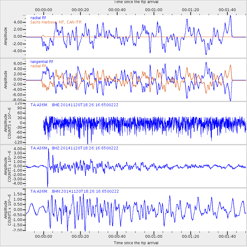
A36M Sachs Harbour, NT, CAN - Earthquake Result Viewer
*The percent match for this event was below the threshold and hence no stack was calculated.
| Earthquake location: |
Myanmar-India Border Region |
| Earthquake latitude/longitude: |
23.5/93.5 |
| Earthquake time(UTC): |
2014/11/20 (324) 18:14:37 GMT |
| Earthquake Depth: |
48 km |
| Earthquake Magnitude: |
5.6 MWB |
| Earthquake Catalog/Contributor: |
NEIC PDE/NEIC COMCAT |
|
| Network: |
TA USArray Transportable Network (new EarthScope stations) |
| Station: |
A36M Sachs Harbour, NT, CAN |
| Lat/Lon: |
71.99 N/125.25 W |
| Elevation: |
32 m |
|
| Distance: |
81.1 deg |
| Az: |
11.371 deg |
| Baz: |
324.428 deg |
| Ray Param: |
$rayparam |
*The percent match for this event was below the threshold and hence was not used in the summary stack. |
|
| Radial Match: |
53.471184 % |
| Radial Bump: |
400 |
| Transverse Match: |
53.566017 % |
| Transverse Bump: |
400 |
| SOD ConfigId: |
3390531 |
| Insert Time: |
2019-04-15 03:22:59.207 +0000 |
| GWidth: |
2.5 |
| Max Bumps: |
400 |
| Tol: |
0.001 |
|
Signal To Noise
| Channel | StoN | STA | LTA |
| TA:A36M: :BHZ:20141120T18:26:16.650022Z | 4.038162 | 1.3928367E-6 | 3.4491848E-7 |
| TA:A36M: :BHN:20141120T18:26:16.650022Z | 1.3880364 | 7.177014E-7 | 5.170624E-7 |
| TA:A36M: :BHE:20141120T18:26:16.650022Z | 0.9251597 | 2.6750706E-5 | 2.891469E-5 |
| Arrivals |
| Ps | |
| PpPs | |
| PsPs/PpSs | |


