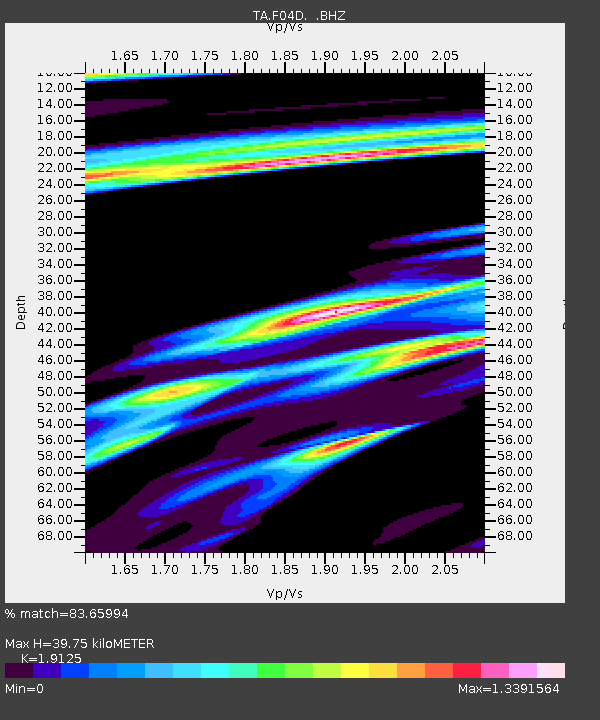
F04D Rainier, OR, USA - Earthquake Result Viewer

Earthquake location: Near Coast Of Chiapas, Mexico
Earthquake latitude/longitude: 14.6/-92.1
Earthquake time(UTC): 2013/09/07 (250) 00:13:29 GMT
Earthquake Depth: 66 km
Earthquake Magnitude: 6.4 MWW, 6.4 MWB, 6.4 MWC, 6.4 MWW, 6.5 MWC
Earthquake Catalog/Contributor: NEIC PDE/NEIC COMCAT
Network: TA USArray Transportable Network (new EarthScope stations)
Station: F04D Rainier, OR, USA
Lat/Lon: 46.08 N/123.01 W
Elevation: 236 m
Distance: 40.7 deg
Az: 326.769 deg
Baz: 130.34 deg
Ray Param: 0.07404925
Estimated Moho Depth: 39.75 km
Estimated Crust Vp/Vs: 1.91
Assumed Crust Vp: 6.566 km/s
Estimated Crust Vs: 3.433 km/s
Estimated Crust Poisson's Ratio: 0.31
Radial Match: 83.65994 %
Radial Bump: 400
Transverse Match: 73.56447 %
Transverse Bump: 400
SOD ConfigId: 626651
Insert Time: 2014-04-18 15:05:05.896 +0000
GWidth: 2.5
Max Bumps: 400
Tol: 0.001

Signal To Noise

ChannelStoNSTALTA
TA:F04D: :BHZ:20130907T00:20:33.223992Z2.72218289.2617455E-73.402323E-7
TA:F04D: :BHN:20130907T00:20:33.223992Z2.40517959.624033E-74.0013785E-7
TA:F04D: :BHE:20130907T00:20:33.223992Z1.33907476.438228E-74.8079676E-7
Arrivals
Ps5.9 SECOND
PpPs16 SECOND
PsPs/PpSs22 SECOND