F57A Harrington, QC, CAN - Earthquake Result Viewer
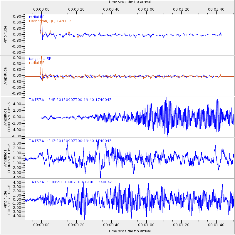
Earthquake location: Near Coast Of Chiapas, Mexico
Earthquake latitude/longitude: 14.6/-92.1
Earthquake time(UTC): 2013/09/07 (250) 00:13:29 GMT
Earthquake Depth: 66 km
Earthquake Magnitude: 6.4 MWW, 6.4 MWB, 6.4 MWC, 6.4 MWW, 6.5 MWC
Earthquake Catalog/Contributor: NEIC PDE/NEIC COMCAT
Network: TA USArray Transportable Network (new EarthScope stations)
Station: F57A Harrington, QC, CAN
Lat/Lon: 45.81 N/74.69 W
Elevation: 178 m
Distance: 34.4 deg
Az: 21.764 deg
Baz: 210.878 deg
Ray Param: 0.07757911
Estimated Moho Depth: 13.0 km
Estimated Crust Vp/Vs: 2.09
Assumed Crust Vp: 6.419 km/s
Estimated Crust Vs: 3.079 km/s
Estimated Crust Poisson's Ratio: 0.35
Radial Match: 85.275406 %
Radial Bump: 400
Transverse Match: 47.59251 %
Transverse Bump: 400
SOD ConfigId: 626651
Insert Time: 2014-04-18 15:05:33.958 +0000
GWidth: 2.5
Max Bumps: 400
Tol: 0.001

Signal To Noise

ChannelStoNSTALTA
TA:F57A: :BHZ:20130907T00:19:40.174004Z4.49052438.4294334E-71.8771603E-7
TA:F57A: :BHN:20130907T00:19:40.174004Z4.51656068.9239586E-71.9758306E-7
TA:F57A: :BHE:20130907T00:19:40.174004Z2.25685335.336213E-72.3644482E-7
Arrivals
Ps2.3 SECOND
PpPs5.9 SECOND
PsPs/PpSs8.2 SECOND