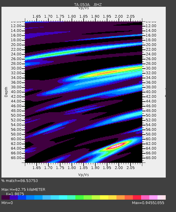
G53A Haliburton, ON, CAN - Earthquake Result Viewer

Earthquake location: Near Coast Of Chiapas, Mexico
Earthquake latitude/longitude: 14.6/-92.1
Earthquake time(UTC): 2013/09/07 (250) 00:13:29 GMT
Earthquake Depth: 66 km
Earthquake Magnitude: 6.4 MWW, 6.4 MWB, 6.4 MWC, 6.4 MWW, 6.5 MWC
Earthquake Catalog/Contributor: NEIC PDE/NEIC COMCAT
Network: TA USArray Transportable Network (new EarthScope stations)
Station: G53A Haliburton, ON, CAN
Lat/Lon: 45.12 N/78.62 W
Elevation: 333 m
Distance: 32.5 deg
Az: 17.913 deg
Baz: 204.871 deg
Ray Param: 0.078474455
Estimated Moho Depth: 62.75 km
Estimated Crust Vp/Vs: 1.99
Assumed Crust Vp: 6.577 km/s
Estimated Crust Vs: 3.309 km/s
Estimated Crust Poisson's Ratio: 0.33
Radial Match: 86.53753 %
Radial Bump: 360
Transverse Match: 64.63444 %
Transverse Bump: 400
SOD ConfigId: 626651
Insert Time: 2014-04-18 15:06:10.762 +0000
GWidth: 2.5
Max Bumps: 400
Tol: 0.001

Signal To Noise

ChannelStoNSTALTA
TA:G53A: :BHZ:20130907T00:19:23.675011Z3.29994426.886884E-72.0869699E-7
TA:G53A: :BHN:20130907T00:19:23.675011Z1.76857863.620609E-72.0471856E-7
TA:G53A: :BHE:20130907T00:19:23.675011Z1.13731492.2153645E-71.9478901E-7
Arrivals
Ps10 SECOND
PpPs26 SECOND
PsPs/PpSs37 SECOND