You are here: Home > Network List > XJ13 - CRAFTI Stations List
> Station PR61 Kiloki Boma > Earthquake Result Viewer
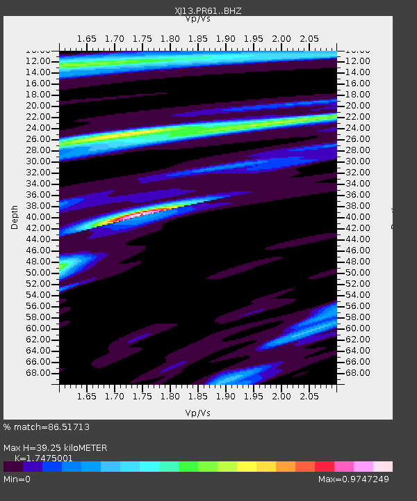
PR61 Kiloki Boma - Earthquake Result Viewer
| Earthquake location: |
Myanmar-India Border Region |
| Earthquake latitude/longitude: |
23.5/93.5 |
| Earthquake time(UTC): |
2014/11/20 (324) 18:14:37 GMT |
| Earthquake Depth: |
48 km |
| Earthquake Magnitude: |
5.6 MWB |
| Earthquake Catalog/Contributor: |
NEIC PDE/NEIC COMCAT |
|
| Network: |
XJ CRAFTI |
| Station: |
PR61 Kiloki Boma |
| Lat/Lon: |
2.96 S/35.25 E |
| Elevation: |
1549 m |
|
| Distance: |
62.5 deg |
| Az: |
253.262 deg |
| Baz: |
61.665 deg |
| Ray Param: |
0.060084112 |
| Estimated Moho Depth: |
39.25 km |
| Estimated Crust Vp/Vs: |
1.75 |
| Assumed Crust Vp: |
6.576 km/s |
| Estimated Crust Vs: |
3.763 km/s |
| Estimated Crust Poisson's Ratio: |
0.26 |
|
| Radial Match: |
86.51713 % |
| Radial Bump: |
400 |
| Transverse Match: |
39.49975 % |
| Transverse Bump: |
400 |
| SOD ConfigId: |
3390531 |
| Insert Time: |
2019-04-15 03:23:19.212 +0000 |
| GWidth: |
2.5 |
| Max Bumps: |
400 |
| Tol: |
0.001 |
|

Signal To Noise
| Channel | StoN | STA | LTA |
| XJ:PR61: :BHZ:20141120T18:24:25.440Z | 6.5133934 | 2.9244148E-7 | 4.489848E-8 |
| XJ:PR61: :BHN:20141120T18:24:25.440Z | 2.0169468 | 9.944902E-8 | 4.9306713E-8 |
| XJ:PR61: :BHE:20141120T18:24:25.440Z | 2.1160316 | 1.4779094E-7 | 6.9843445E-8 |
| Arrivals |
| Ps | 4.7 SECOND |
| PpPs | 16 SECOND |
| PsPs/PpSs | 20 SECOND |


