You are here: Home > Network List > TA - USArray Transportable Network (new EarthScope stations) Stations List
> Station H43A Windswept, Luxemburg, WI, USA > Earthquake Result Viewer
H43A Windswept, Luxemburg, WI, USA - Earthquake Result Viewer

| Earthquake location: |
Near Coast Of Chiapas, Mexico |
| Earthquake latitude/longitude: |
14.6/-92.1 |
| Earthquake time(UTC): |
2013/09/07 (250) 00:13:29 GMT |
| Earthquake Depth: |
66 km |
| Earthquake Magnitude: |
6.4 MWW, 6.4 MWB, 6.4 MWC, 6.4 MWW, 6.5 MWC |
| Earthquake Catalog/Contributor: |
NEIC PDE/NEIC COMCAT |
|
| Network: |
TA USArray Transportable Network (new EarthScope stations) |
| Station: |
H43A Windswept, Luxemburg, WI, USA |
| Lat/Lon: |
44.47 N/87.77 W |
| Elevation: |
274 m |
|
| Distance: |
30.0 deg |
| Az: |
6.237 deg |
| Baz: |
188.447 deg |
| Ray Param: |
0.07935255 |
| Estimated Moho Depth: |
37.0 km |
| Estimated Crust Vp/Vs: |
1.81 |
| Assumed Crust Vp: |
6.53 km/s |
| Estimated Crust Vs: |
3.613 km/s |
| Estimated Crust Poisson's Ratio: |
0.28 |
|
| Radial Match: |
90.9536 % |
| Radial Bump: |
251 |
| Transverse Match: |
57.03443 % |
| Transverse Bump: |
400 |
| SOD ConfigId: |
626651 |
| Insert Time: |
2014-04-18 15:06:45.385 +0000 |
| GWidth: |
2.5 |
| Max Bumps: |
400 |
| Tol: |
0.001 |
|
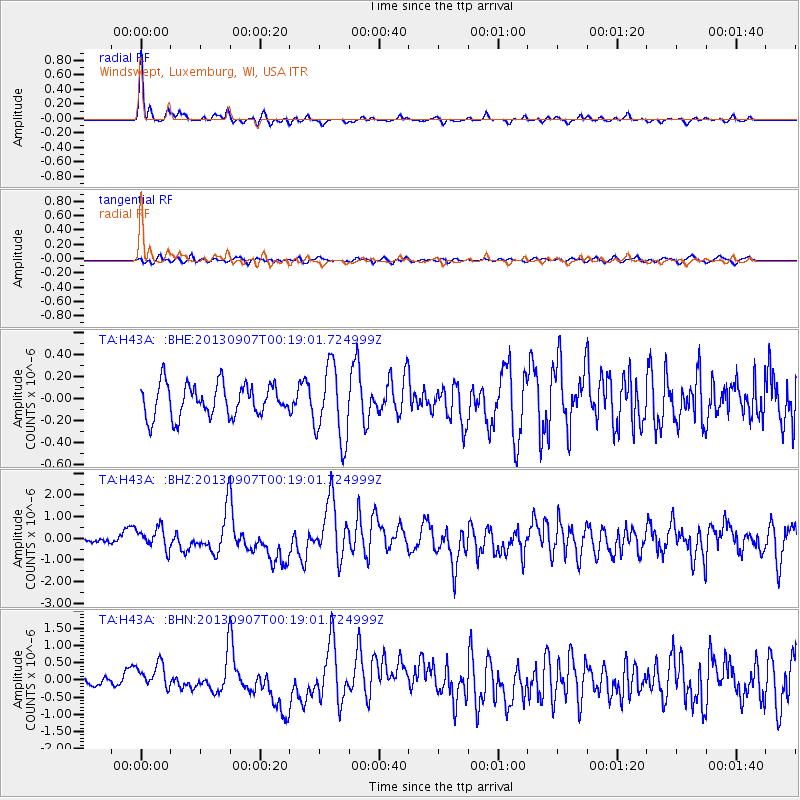
Signal To Noise
| Channel | StoN | STA | LTA |
| TA:H43A: :BHZ:20130907T00:19:01.724999Z | 2.5973501 | 4.966943E-7 | 1.9123118E-7 |
| TA:H43A: :BHN:20130907T00:19:01.724999Z | 2.8219683 | 3.7767984E-7 | 1.338356E-7 |
| TA:H43A: :BHE:20130907T00:19:01.724999Z | 2.2925522 | 3.3858376E-7 | 1.4768858E-7 |
| Arrivals |
| Ps | 5.0 SECOND |
| PpPs | 15 SECOND |
| PsPs/PpSs | 20 SECOND |


