H48A Harrisville, MI, USA - Earthquake Result Viewer
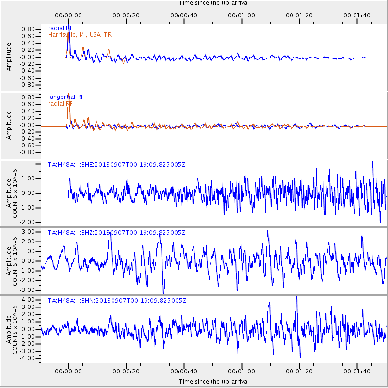
Earthquake location: Near Coast Of Chiapas, Mexico
Earthquake latitude/longitude: 14.6/-92.1
Earthquake time(UTC): 2013/09/07 (250) 00:13:29 GMT
Earthquake Depth: 66 km
Earthquake Magnitude: 6.4 MWW, 6.4 MWB, 6.4 MWC, 6.4 MWW, 6.5 MWC
Earthquake Catalog/Contributor: NEIC PDE/NEIC COMCAT
Network: TA USArray Transportable Network (new EarthScope stations)
Station: H48A Harrisville, MI, USA
Lat/Lon: 44.70 N/83.32 W
Elevation: 244 m
Distance: 30.9 deg
Az: 12.255 deg
Baz: 196.747 deg
Ray Param: 0.07911157
Estimated Moho Depth: 17.75 km
Estimated Crust Vp/Vs: 1.72
Assumed Crust Vp: 6.483 km/s
Estimated Crust Vs: 3.769 km/s
Estimated Crust Poisson's Ratio: 0.24
Radial Match: 86.28892 %
Radial Bump: 400
Transverse Match: 54.85417 %
Transverse Bump: 400
SOD ConfigId: 626651
Insert Time: 2014-04-18 15:06:52.412 +0000
GWidth: 2.5
Max Bumps: 400
Tol: 0.001

Signal To Noise

ChannelStoNSTALTA
TA:H48A: :BHZ:20130907T00:19:09.825005Z2.02775227.791356E-73.842361E-7
TA:H48A: :BHN:20130907T00:19:09.825005Z1.85146735.443451E-72.940074E-7
TA:H48A: :BHE:20130907T00:19:09.825005Z0.707498972.5258396E-73.5700964E-7
Arrivals
Ps2.1 SECOND
PpPs6.8 SECOND
PsPs/PpSs9.0 SECOND