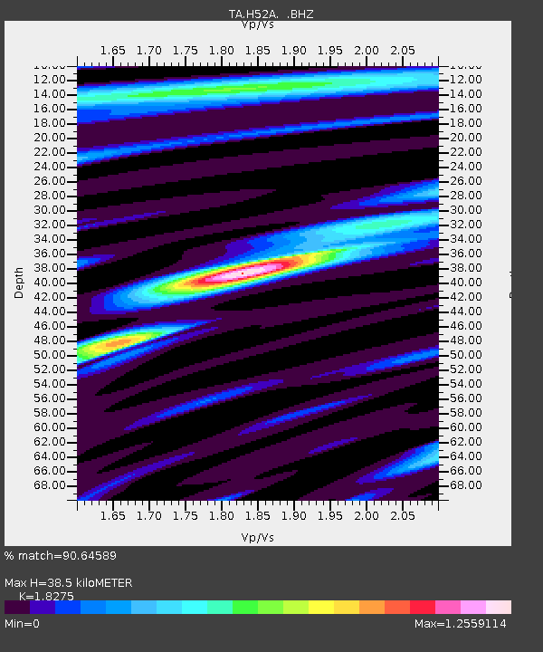
H52A Wyevale, ON, CAN - Earthquake Result Viewer
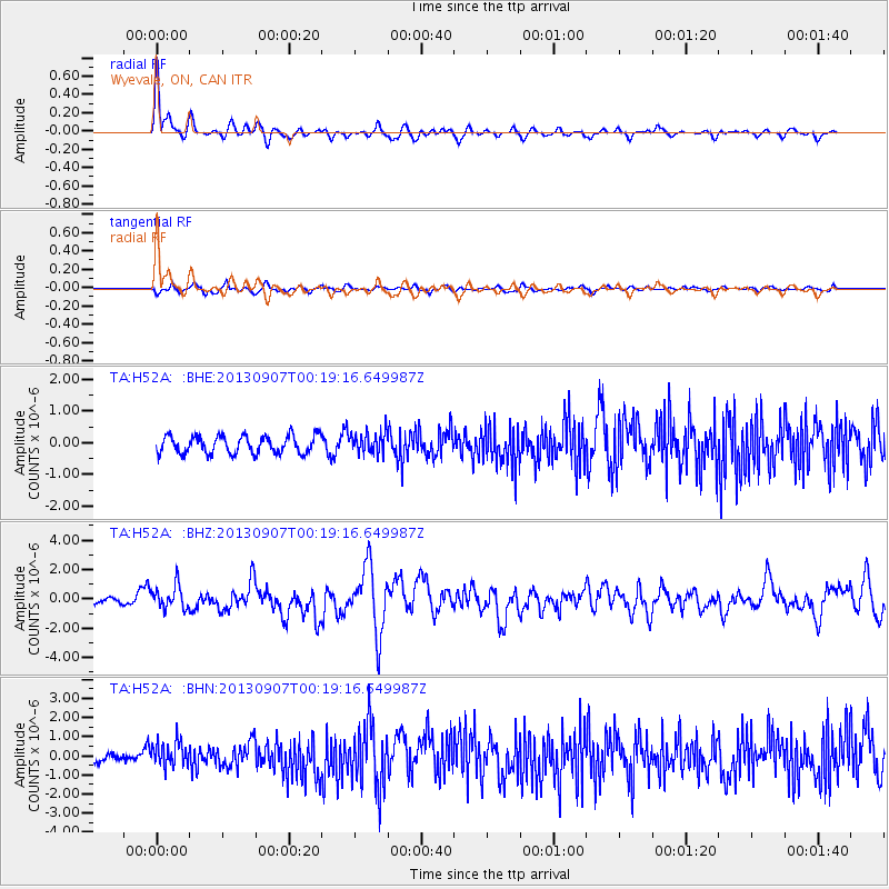
Earthquake location: Near Coast Of Chiapas, Mexico
Earthquake latitude/longitude: 14.6/-92.1
Earthquake time(UTC): 2013/09/07 (250) 00:13:29 GMT
Earthquake Depth: 66 km
Earthquake Magnitude: 6.4 MWW, 6.4 MWB, 6.4 MWC, 6.4 MWW, 6.5 MWC
Earthquake Catalog/Contributor: NEIC PDE/NEIC COMCAT
Network: TA USArray Transportable Network (new EarthScope stations)
Station: H52A Wyevale, ON, CAN
Lat/Lon: 44.64 N/79.89 W
Elevation: 209 m
Distance: 31.7 deg
Az: 16.732 deg
Baz: 202.98 deg
Ray Param: 0.07881511
Estimated Moho Depth: 38.5 km
Estimated Crust Vp/Vs: 1.83
Assumed Crust Vp: 6.577 km/s
Estimated Crust Vs: 3.599 km/s
Estimated Crust Poisson's Ratio: 0.29
Radial Match: 90.64589 %
Radial Bump: 394
Transverse Match: 59.6253 %
Transverse Bump: 400
SOD ConfigId: 626651
Insert Time: 2014-04-18 15:06:52.869 +0000
GWidth: 2.5
Max Bumps: 400
Tol: 0.001

Signal To Noise

ChannelStoNSTALTA
TA:H52A: :BHZ:20130907T00:19:16.649987Z3.95214927.877352E-71.9931818E-7
TA:H52A: :BHN:20130907T00:19:16.649987Z3.49882256.329977E-71.8091734E-7
TA:H52A: :BHE:20130907T00:19:16.649987Z1.19043533.2948336E-72.7677555E-7
Arrivals
Ps5.3 SECOND
PpPs15 SECOND
PsPs/PpSs21 SECOND