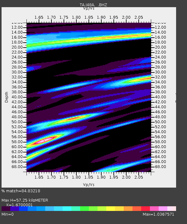
I48A Sherman Twp, MI, USA - Earthquake Result Viewer

Earthquake location: Near Coast Of Chiapas, Mexico
Earthquake latitude/longitude: 14.6/-92.1
Earthquake time(UTC): 2013/09/07 (250) 00:13:29 GMT
Earthquake Depth: 66 km
Earthquake Magnitude: 6.4 MWW, 6.4 MWB, 6.4 MWC, 6.4 MWW, 6.5 MWC
Earthquake Catalog/Contributor: NEIC PDE/NEIC COMCAT
Network: TA USArray Transportable Network (new EarthScope stations)
Station: I48A Sherman Twp, MI, USA
Lat/Lon: 44.19 N/83.70 W
Elevation: 192 m
Distance: 30.3 deg
Az: 12.033 deg
Baz: 196.292 deg
Ray Param: 0.07926074
Estimated Moho Depth: 57.25 km
Estimated Crust Vp/Vs: 1.67
Assumed Crust Vp: 6.483 km/s
Estimated Crust Vs: 3.882 km/s
Estimated Crust Poisson's Ratio: 0.22
Radial Match: 84.83218 %
Radial Bump: 372
Transverse Match: 53.829998 %
Transverse Bump: 400
SOD ConfigId: 626651
Insert Time: 2014-04-18 15:07:27.306 +0000
GWidth: 2.5
Max Bumps: 400
Tol: 0.001

Signal To Noise

ChannelStoNSTALTA
TA:I48A: :BHZ:20130907T00:19:04.800011Z2.12347826.454079E-73.0393906E-7
TA:I48A: :BHN:20130907T00:19:04.800011Z2.66256835.269989E-71.9792878E-7
TA:I48A: :BHE:20130907T00:19:04.800011Z0.70429122.412023E-73.424752E-7
Arrivals
Ps6.5 SECOND
PpPs22 SECOND
PsPs/PpSs28 SECOND