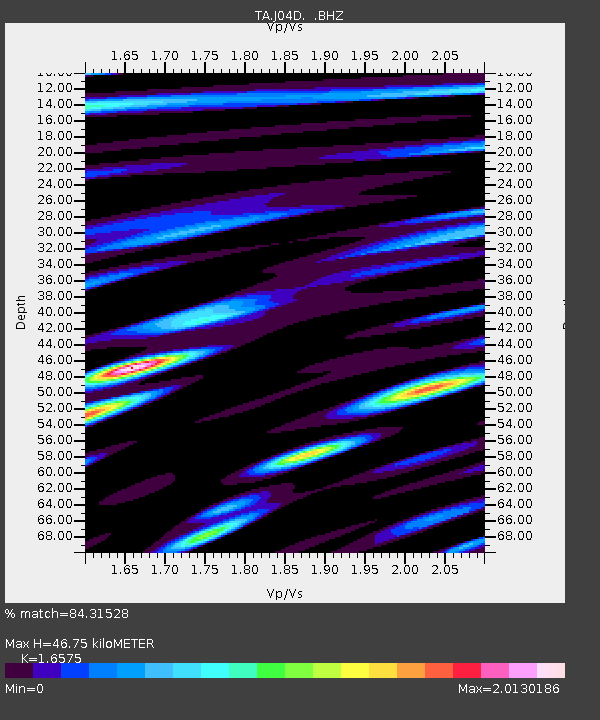
J04D Umpqua National Forest, Toketee, OR, USA - Earthquake Result Viewer

Earthquake location: Near Coast Of Chiapas, Mexico
Earthquake latitude/longitude: 14.6/-92.1
Earthquake time(UTC): 2013/09/07 (250) 00:13:29 GMT
Earthquake Depth: 66 km
Earthquake Magnitude: 6.4 MWW, 6.4 MWB, 6.4 MWC, 6.4 MWW, 6.5 MWC
Earthquake Catalog/Contributor: NEIC PDE/NEIC COMCAT
Network: TA USArray Transportable Network (new EarthScope stations)
Station: J04D Umpqua National Forest, Toketee, OR, USA
Lat/Lon: 43.24 N/122.11 W
Elevation: 1948 m
Distance: 38.4 deg
Az: 323.973 deg
Baz: 128.814 deg
Ray Param: 0.075394586
Estimated Moho Depth: 46.75 km
Estimated Crust Vp/Vs: 1.66
Assumed Crust Vp: 6.522 km/s
Estimated Crust Vs: 3.935 km/s
Estimated Crust Poisson's Ratio: 0.21
Radial Match: 84.31528 %
Radial Bump: 400
Transverse Match: 88.19476 %
Transverse Bump: 400
SOD ConfigId: 626651
Insert Time: 2014-04-18 15:07:48.714 +0000
GWidth: 2.5
Max Bumps: 400
Tol: 0.001

Signal To Noise

ChannelStoNSTALTA
TA:J04D: :BHZ:20130907T00:20:14.099999Z3.64660556.779955E-71.859251E-7
TA:J04D: :BHN:20130907T00:20:14.099999Z0.85031393.2956257E-73.8757756E-7
TA:J04D: :BHE:20130907T00:20:14.099999Z1.0450414.072688E-73.8971564E-7
Arrivals
Ps5.1 SECOND
PpPs18 SECOND
PsPs/PpSs23 SECOND