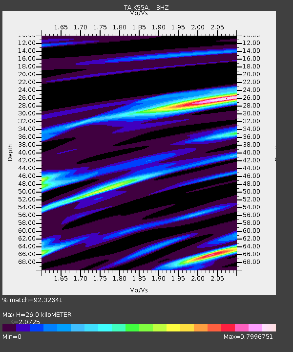
K55A Perry, NY, USA - Earthquake Result Viewer
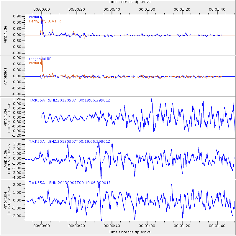
Earthquake location: Near Coast Of Chiapas, Mexico
Earthquake latitude/longitude: 14.6/-92.1
Earthquake time(UTC): 2013/09/07 (250) 00:13:29 GMT
Earthquake Depth: 66 km
Earthquake Magnitude: 6.4 MWW, 6.4 MWB, 6.4 MWC, 6.4 MWW, 6.5 MWC
Earthquake Catalog/Contributor: NEIC PDE/NEIC COMCAT
Network: TA USArray Transportable Network (new EarthScope stations)
Station: K55A Perry, NY, USA
Lat/Lon: 42.73 N/78.07 W
Elevation: 482 m
Distance: 30.5 deg
Az: 20.623 deg
Baz: 207.565 deg
Ray Param: 0.07921356
Estimated Moho Depth: 26.0 km
Estimated Crust Vp/Vs: 2.07
Assumed Crust Vp: 6.419 km/s
Estimated Crust Vs: 3.097 km/s
Estimated Crust Poisson's Ratio: 0.35
Radial Match: 92.32641 %
Radial Bump: 253
Transverse Match: 68.88656 %
Transverse Bump: 400
SOD ConfigId: 626651
Insert Time: 2014-04-18 15:08:32.956 +0000
GWidth: 2.5
Max Bumps: 400
Tol: 0.001

Signal To Noise

ChannelStoNSTALTA
TA:K55A: :BHZ:20130907T00:19:06.39901Z5.0987718.8139666E-71.7286453E-7
TA:K55A: :BHN:20130907T00:19:06.39901Z3.47348385.285745E-71.5217417E-7
TA:K55A: :BHE:20130907T00:19:06.39901Z1.38873462.1245289E-71.5298309E-7
Arrivals
Ps4.7 SECOND
PpPs12 SECOND
PsPs/PpSs16 SECOND