You are here: Home > Network List > YB13 - Continental Dynamics/Cent. Anatolian Tectonics:Surface to Mantle Dynamics During Stations List
> Station AT34 Yesilkoy,Adana,Turkey > Earthquake Result Viewer
AT34 Yesilkoy,Adana,Turkey - Earthquake Result Viewer
| Earthquake location: |
Myanmar-India Border Region |
| Earthquake latitude/longitude: |
23.5/93.5 |
| Earthquake time(UTC): |
2014/11/20 (324) 18:14:37 GMT |
| Earthquake Depth: |
48 km |
| Earthquake Magnitude: |
5.6 MWB |
| Earthquake Catalog/Contributor: |
NEIC PDE/NEIC COMCAT |
|
| Network: |
YB Continental Dynamics/Cent. Anatolian Tectonics:Surface to Mantle Dynamics During |
| Station: |
AT34 Yesilkoy,Adana,Turkey |
| Lat/Lon: |
37.91 N/35.51 E |
| Elevation: |
1097 m |
|
| Distance: |
51.1 deg |
| Az: |
300.507 deg |
| Baz: |
88.801 deg |
| Ray Param: |
0.06749018 |
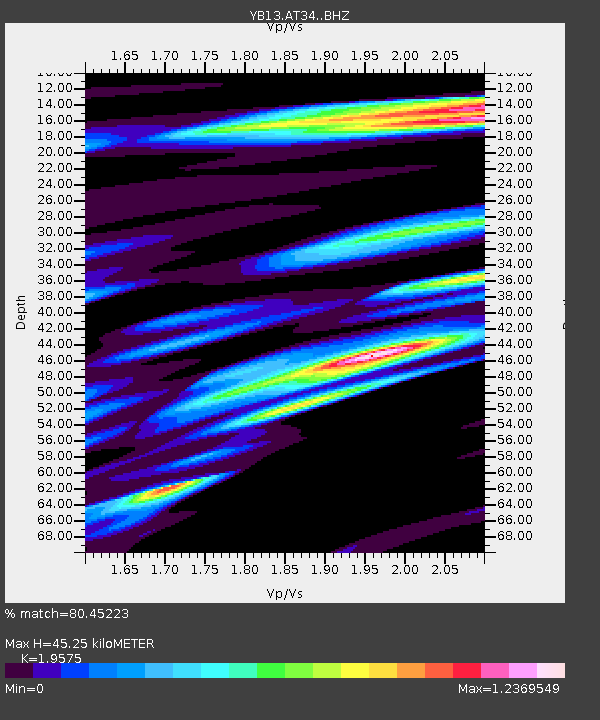
| Estimated Moho Depth: |
45.25 km |
| Estimated Crust Vp/Vs: |
1.96 |
| Assumed Crust Vp: |
6.247 km/s |
| Estimated Crust Vs: |
3.191 km/s |
| Estimated Crust Poisson's Ratio: |
0.32 |
|
| Radial Match: |
80.45223 % |
| Radial Bump: |
400 |
| Transverse Match: |
69.2923 % |
| Transverse Bump: |
400 |
| SOD ConfigId: |
3390531 |
| Insert Time: |
2019-04-15 03:23:44.124 +0000 |
| GWidth: |
2.5 |
| Max Bumps: |
400 |
| Tol: |
0.001 |
|

Signal To Noise
| Channel | StoN | STA | LTA |
| YB:AT34: :BHZ:20141120T18:23:05.01901Z | 5.874406 | 3.2951587E-7 | 5.6093484E-8 |
| YB:AT34: :BHN:20141120T18:23:05.01901Z | 1.812898 | 9.407672E-8 | 5.1893E-8 |
| YB:AT34: :BHE:20141120T18:23:05.01901Z | 2.699392 | 1.482971E-7 | 5.4937225E-8 |
| Arrivals |
| Ps | 7.3 SECOND |
| PpPs | 20 SECOND |
| PsPs/PpSs | 28 SECOND |


