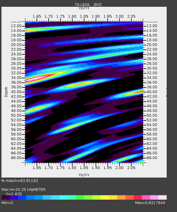
L62A Suffield, CT, USA - Earthquake Result Viewer

Earthquake location: Near Coast Of Chiapas, Mexico
Earthquake latitude/longitude: 14.6/-92.1
Earthquake time(UTC): 2013/09/07 (250) 00:13:29 GMT
Earthquake Depth: 66 km
Earthquake Magnitude: 6.4 MWW, 6.4 MWB, 6.4 MWC, 6.4 MWW, 6.5 MWC
Earthquake Catalog/Contributor: NEIC PDE/NEIC COMCAT
Network: TA USArray Transportable Network (new EarthScope stations)
Station: L62A Suffield, CT, USA
Lat/Lon: 42.03 N/72.66 W
Elevation: 49 m
Distance: 32.1 deg
Az: 27.848 deg
Baz: 217.374 deg
Ray Param: 0.07864528
Estimated Moho Depth: 34.25 km
Estimated Crust Vp/Vs: 1.63
Assumed Crust Vp: 6.419 km/s
Estimated Crust Vs: 3.926 km/s
Estimated Crust Poisson's Ratio: 0.20
Radial Match: 93.91182 %
Radial Bump: 370
Transverse Match: 75.44743 %
Transverse Bump: 400
SOD ConfigId: 626651
Insert Time: 2014-04-18 15:09:02.336 +0000
GWidth: 2.5
Max Bumps: 400
Tol: 0.001

Signal To Noise

ChannelStoNSTALTA
TA:L62A: :BHZ:20130907T00:19:20.14901Z3.56467348.5433453E-72.3966697E-7
TA:L62A: :BHN:20130907T00:19:20.14901Z1.20815738.768792E-77.257989E-7
TA:L62A: :BHE:20130907T00:19:20.14901Z1.44160598.166991E-75.665204E-7
Arrivals
Ps3.7 SECOND
PpPs13 SECOND
PsPs/PpSs17 SECOND