You are here: Home > Network List > TA - USArray Transportable Network (new EarthScope stations) Stations List
> Station MDND Maddock, ND, USA > Earthquake Result Viewer
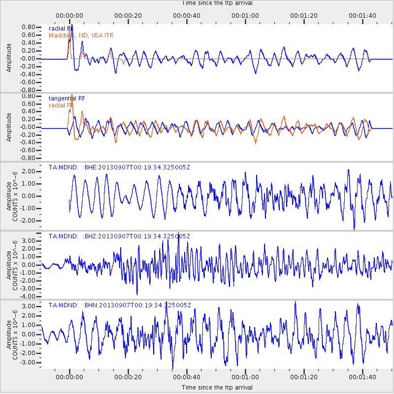
MDND Maddock, ND, USA - Earthquake Result Viewer
*The percent match for this event was below the threshold and hence no stack was calculated.
| Earthquake location: |
Near Coast Of Chiapas, Mexico |
| Earthquake latitude/longitude: |
14.6/-92.1 |
| Earthquake time(UTC): |
2013/09/07 (250) 00:13:29 GMT |
| Earthquake Depth: |
66 km |
| Earthquake Magnitude: |
6.4 MWW, 6.4 MWB, 6.4 MWC, 6.4 MWW, 6.5 MWC |
| Earthquake Catalog/Contributor: |
NEIC PDE/NEIC COMCAT |
|
| Network: |
TA USArray Transportable Network (new EarthScope stations) |
| Station: |
MDND Maddock, ND, USA |
| Lat/Lon: |
47.85 N/99.60 W |
| Elevation: |
479 m |
|
| Distance: |
33.7 deg |
| Az: |
350.91 deg |
| Baz: |
166.875 deg |
| Ray Param: |
$rayparam |
*The percent match for this event was below the threshold and hence was not used in the summary stack. |
|
| Radial Match: |
73.84034 % |
| Radial Bump: |
400 |
| Transverse Match: |
42.397804 % |
| Transverse Bump: |
400 |
| SOD ConfigId: |
626651 |
| Insert Time: |
2014-04-18 15:09:29.021 +0000 |
| GWidth: |
2.5 |
| Max Bumps: |
400 |
| Tol: |
0.001 |
|
Signal To Noise
| Channel | StoN | STA | LTA |
| TA:MDND: :BHZ:20130907T00:19:34.325005Z | 2.7842479 | 5.706595E-7 | 2.0496002E-7 |
| TA:MDND: :BHN:20130907T00:19:34.325005Z | 1.3723109 | 1.2232242E-6 | 8.913608E-7 |
| TA:MDND: :BHE:20130907T00:19:34.325005Z | 1.160599 | 1.1082644E-6 | 9.549073E-7 |
| Arrivals |
| Ps | |
| PpPs | |
| PsPs/PpSs | |


