You are here: Home > Network List > TA - USArray Transportable Network (new EarthScope stations) Stations List
> Station R11A Troy Canyon, Currant, NV, USA > Earthquake Result Viewer
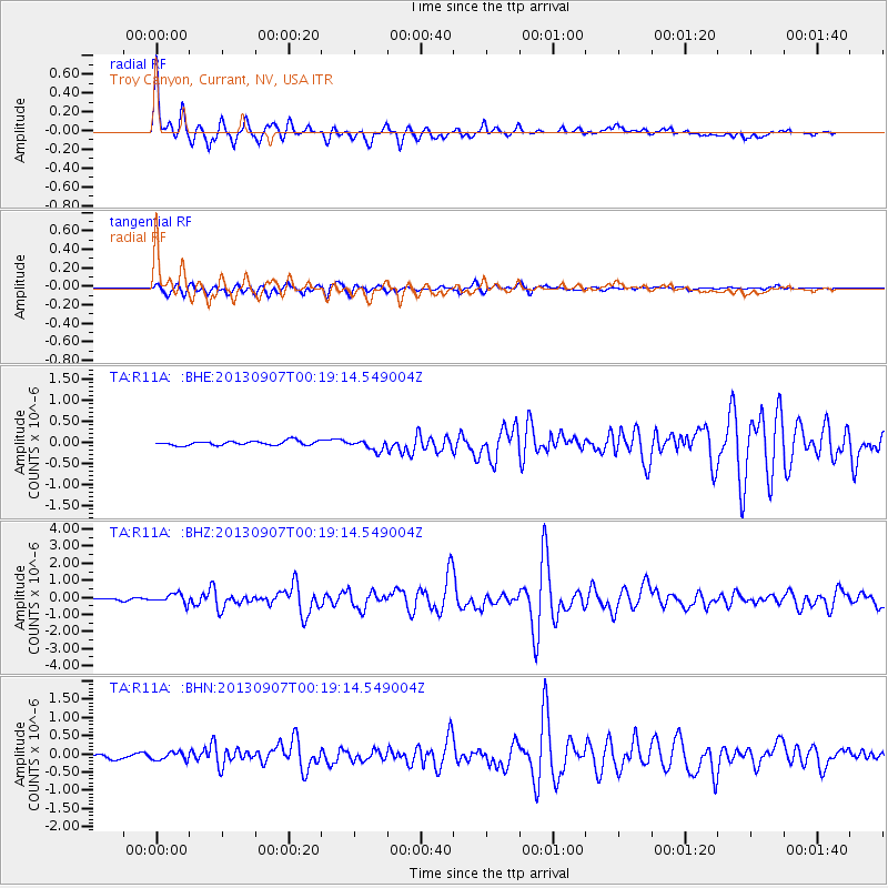
R11A Troy Canyon, Currant, NV, USA - Earthquake Result Viewer

| Earthquake location: |
Near Coast Of Chiapas, Mexico |
| Earthquake latitude/longitude: |
14.6/-92.1 |
| Earthquake time(UTC): |
2013/09/07 (250) 00:13:29 GMT |
| Earthquake Depth: |
66 km |
| Earthquake Magnitude: |
6.4 MWW, 6.4 MWB, 6.4 MWC, 6.4 MWW, 6.5 MWC |
| Earthquake Catalog/Contributor: |
NEIC PDE/NEIC COMCAT |
|
| Network: |
TA USArray Transportable Network (new EarthScope stations) |
| Station: |
R11A Troy Canyon, Currant, NV, USA |
| Lat/Lon: |
38.35 N/115.59 W |
| Elevation: |
1756 m |
|
| Distance: |
31.5 deg |
| Az: |
323.13 deg |
| Baz: |
132.375 deg |
| Ray Param: |
0.07891673 |
| Estimated Moho Depth: |
61.25 km |
| Estimated Crust Vp/Vs: |
1.96 |
| Assumed Crust Vp: |
6.276 km/s |
| Estimated Crust Vs: |
3.21 km/s |
| Estimated Crust Poisson's Ratio: |
0.32 |
|
| Radial Match: |
94.55636 % |
| Radial Bump: |
400 |
| Transverse Match: |
90.58402 % |
| Transverse Bump: |
400 |
| SOD ConfigId: |
626651 |
| Insert Time: |
2014-04-18 15:10:02.131 +0000 |
| GWidth: |
2.5 |
| Max Bumps: |
400 |
| Tol: |
0.001 |
|
Signal To Noise
| Channel | StoN | STA | LTA |
| TA:R11A: :BHZ:20130907T00:19:14.549004Z | 4.5691853 | 2.8523E-7 | 6.24247E-8 |
| TA:R11A: :BHN:20130907T00:19:14.549004Z | 1.7123889 | 1.0681296E-7 | 6.2376586E-8 |
| TA:R11A: :BHE:20130907T00:19:14.549004Z | 2.5691962 | 1.2958914E-7 | 5.043957E-8 |
| Arrivals |
| Ps | 10.0 SECOND |
| PpPs | 27 SECOND |
| PsPs/PpSs | 37 SECOND |


