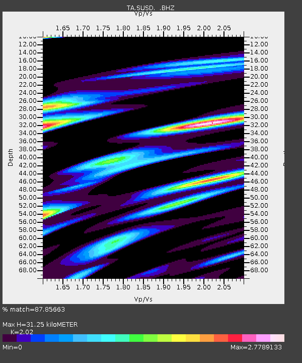
SUSD Miller, SD, USA - Earthquake Result Viewer

Earthquake location: Near Coast Of Chiapas, Mexico
Earthquake latitude/longitude: 14.6/-92.1
Earthquake time(UTC): 2013/09/07 (250) 00:13:29 GMT
Earthquake Depth: 66 km
Earthquake Magnitude: 6.4 MWW, 6.4 MWB, 6.4 MWC, 6.4 MWW, 6.5 MWC
Earthquake Catalog/Contributor: NEIC PDE/NEIC COMCAT
Network: TA USArray Transportable Network (new EarthScope stations)
Station: SUSD Miller, SD, USA
Lat/Lon: 44.44 N/98.96 W
Elevation: 520 m
Distance: 30.3 deg
Az: 350.273 deg
Baz: 166.801 deg
Ray Param: 0.07927181
Estimated Moho Depth: 31.25 km
Estimated Crust Vp/Vs: 2.02
Assumed Crust Vp: 6.53 km/s
Estimated Crust Vs: 3.233 km/s
Estimated Crust Poisson's Ratio: 0.34
Radial Match: 87.85663 %
Radial Bump: 400
Transverse Match: 67.93421 %
Transverse Bump: 400
SOD ConfigId: 626651
Insert Time: 2014-04-18 15:10:09.857 +0000
GWidth: 2.5
Max Bumps: 400
Tol: 0.001

Signal To Noise

ChannelStoNSTALTA
TA:SUSD: :BHZ:20130907T00:19:04.425011Z2.56948833.52956E-71.3736432E-7
TA:SUSD: :BHN:20130907T00:19:04.425011Z1.02064623.2547558E-73.188917E-7
TA:SUSD: :BHE:20130907T00:19:04.425011Z1.07677212.8965147E-72.689998E-7
Arrivals
Ps5.2 SECOND
PpPs13 SECOND
PsPs/PpSs19 SECOND