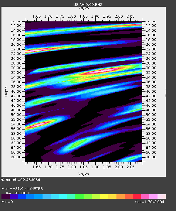
AHID Auburn Hatchery, Idaho, USA - Earthquake Result Viewer
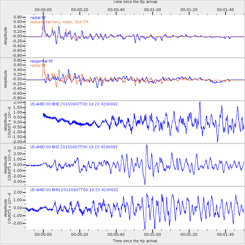
Earthquake location: Near Coast Of Chiapas, Mexico
Earthquake latitude/longitude: 14.6/-92.1
Earthquake time(UTC): 2013/09/07 (250) 00:13:29 GMT
Earthquake Depth: 66 km
Earthquake Magnitude: 6.4 MWW, 6.4 MWB, 6.4 MWC, 6.4 MWW, 6.5 MWC
Earthquake Catalog/Contributor: NEIC PDE/NEIC COMCAT
Network: US United States National Seismic Network
Station: AHID Auburn Hatchery, Idaho, USA
Lat/Lon: 42.77 N/111.10 W
Elevation: 1960 m
Distance: 32.5 deg
Az: 333.504 deg
Baz: 144.091 deg
Ray Param: 0.07848605
Estimated Moho Depth: 31.0 km
Estimated Crust Vp/Vs: 1.93
Assumed Crust Vp: 6.207 km/s
Estimated Crust Vs: 3.216 km/s
Estimated Crust Poisson's Ratio: 0.32
Radial Match: 92.466064 %
Radial Bump: 400
Transverse Match: 74.30866 %
Transverse Bump: 400
SOD ConfigId: 626651
Insert Time: 2014-04-18 15:10:25.846 +0000
GWidth: 2.5
Max Bumps: 400
Tol: 0.001

Signal To Noise

ChannelStoNSTALTA
US:AHID:00:BHZ:20130907T00:19:23.429009Z2.3062862.8067615E-71.217005E-7
US:AHID:00:BHN:20130907T00:19:23.429009Z0.813745562.805235E-73.4473123E-7
US:AHID:00:BHE:20130907T00:19:23.429009Z1.25891273.7507652E-72.9793688E-7
Arrivals
Ps5.0 SECOND
PpPs14 SECOND
PsPs/PpSs19 SECOND