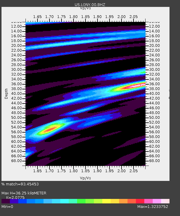
LONY Lake Ozonia, New York, USA - Earthquake Result Viewer
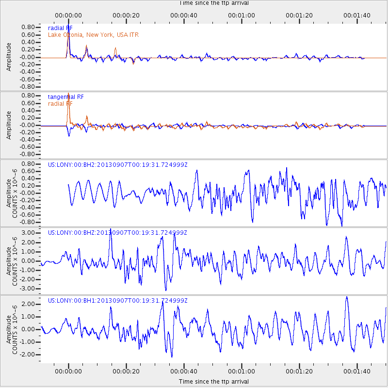
Earthquake location: Near Coast Of Chiapas, Mexico
Earthquake latitude/longitude: 14.6/-92.1
Earthquake time(UTC): 2013/09/07 (250) 00:13:29 GMT
Earthquake Depth: 66 km
Earthquake Magnitude: 6.4 MWW, 6.4 MWB, 6.4 MWC, 6.4 MWW, 6.5 MWC
Earthquake Catalog/Contributor: NEIC PDE/NEIC COMCAT
Network: US United States National Seismic Network
Station: LONY Lake Ozonia, New York, USA
Lat/Lon: 44.62 N/74.58 W
Elevation: 440 m
Distance: 33.4 deg
Az: 22.997 deg
Baz: 211.98 deg
Ray Param: 0.07805072
Estimated Moho Depth: 36.25 km
Estimated Crust Vp/Vs: 2.08
Assumed Crust Vp: 6.419 km/s
Estimated Crust Vs: 3.09 km/s
Estimated Crust Poisson's Ratio: 0.35
Radial Match: 93.45453 %
Radial Bump: 333
Transverse Match: 78.26986 %
Transverse Bump: 349
SOD ConfigId: 626651
Insert Time: 2014-04-18 15:11:06.874 +0000
GWidth: 2.5
Max Bumps: 400
Tol: 0.001

Signal To Noise

ChannelStoNSTALTA
US:LONY:00:BHZ:20130907T00:19:31.724999Z2.90407637.277351E-72.505909E-7
US:LONY:00:BH1:20130907T00:19:31.724999Z2.37964135.2043856E-72.1870461E-7
US:LONY:00:BH2:20130907T00:19:31.724999Z0.615953861.1488797E-71.8652041E-7
Arrivals
Ps6.5 SECOND
PpPs16 SECOND
PsPs/PpSs23 SECOND