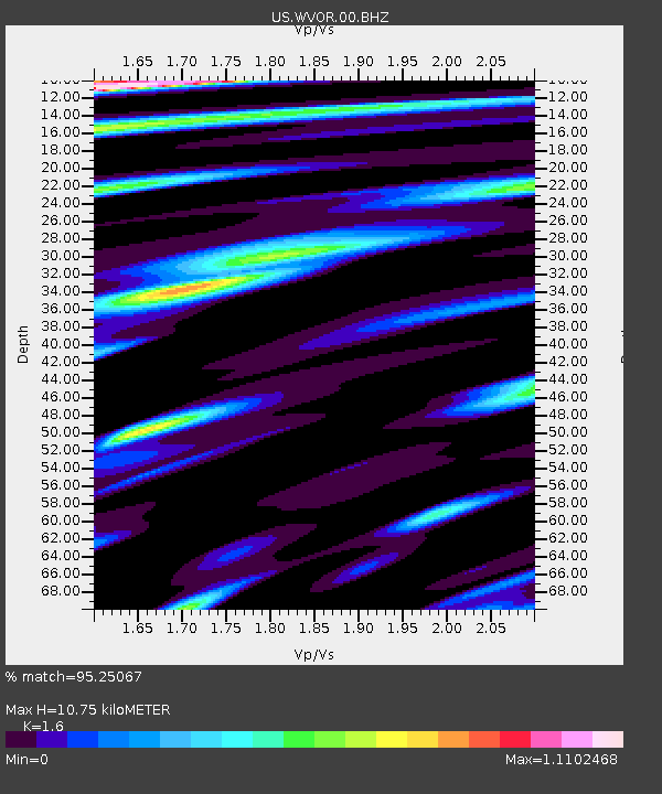
WVOR Wild Horse Valley, Oregon, USA - Earthquake Result Viewer
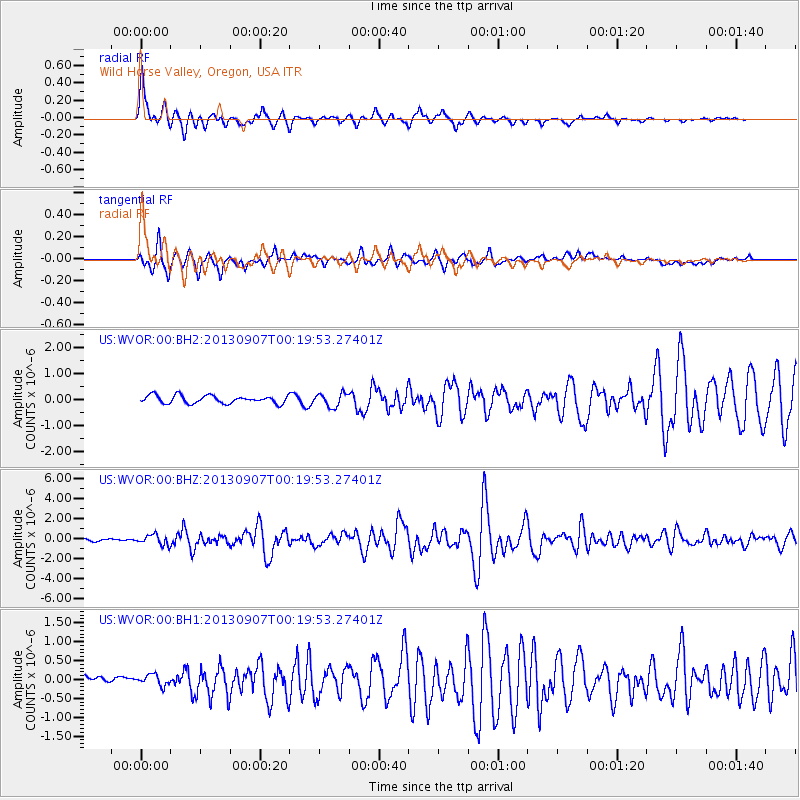
Earthquake location: Near Coast Of Chiapas, Mexico
Earthquake latitude/longitude: 14.6/-92.1
Earthquake time(UTC): 2013/09/07 (250) 00:13:29 GMT
Earthquake Depth: 66 km
Earthquake Magnitude: 6.4 MWW, 6.4 MWB, 6.4 MWC, 6.4 MWW, 6.5 MWC
Earthquake Catalog/Contributor: NEIC PDE/NEIC COMCAT
Network: US United States National Seismic Network
Station: WVOR Wild Horse Valley, Oregon, USA
Lat/Lon: 42.43 N/118.64 W
Elevation: 1344 m
Distance: 35.9 deg
Az: 325.717 deg
Baz: 132.558 deg
Ray Param: 0.07676968
Estimated Moho Depth: 10.75 km
Estimated Crust Vp/Vs: 1.60
Assumed Crust Vp: 6.279 km/s
Estimated Crust Vs: 3.924 km/s
Estimated Crust Poisson's Ratio: 0.18
Radial Match: 95.25067 %
Radial Bump: 400
Transverse Match: 92.00105 %
Transverse Bump: 400
SOD ConfigId: 626651
Insert Time: 2014-04-18 15:11:29.243 +0000
GWidth: 2.5
Max Bumps: 400
Tol: 0.001

Signal To Noise

ChannelStoNSTALTA
US:WVOR:00:BHZ:20130907T00:19:53.27401Z6.02967645.0262446E-78.3358444E-8
US:WVOR:00:BH1:20130907T00:19:53.27401Z1.33391641.4902668E-71.1172116E-7
US:WVOR:00:BH2:20130907T00:19:53.27401Z1.72827952.5808248E-71.4932914E-7
Arrivals
Ps1.1 SECOND
PpPs4.1 SECOND
PsPs/PpSs5.2 SECOND