You are here: Home > Network List > YQ13 - Study of Extension and Magmatism in Malawi and Tanzania Stations List
> Station LOSI Makongolosi,Tanzania > Earthquake Result Viewer
LOSI Makongolosi,Tanzania - Earthquake Result Viewer
| Earthquake location: |
Myanmar-India Border Region |
| Earthquake latitude/longitude: |
23.5/93.5 |
| Earthquake time(UTC): |
2014/11/20 (324) 18:14:37 GMT |
| Earthquake Depth: |
48 km |
| Earthquake Magnitude: |
5.6 MWB |
| Earthquake Catalog/Contributor: |
NEIC PDE/NEIC COMCAT |
|
| Network: |
YQ Study of Extension and Magmatism in Malawi and Tanzania |
| Station: |
LOSI Makongolosi,Tanzania |
| Lat/Lon: |
8.39 S/33.17 E |
| Elevation: |
1233 m |
|
| Distance: |
66.9 deg |
| Az: |
249.166 deg |
| Baz: |
60.118 deg |
| Ray Param: |
0.057189845 |
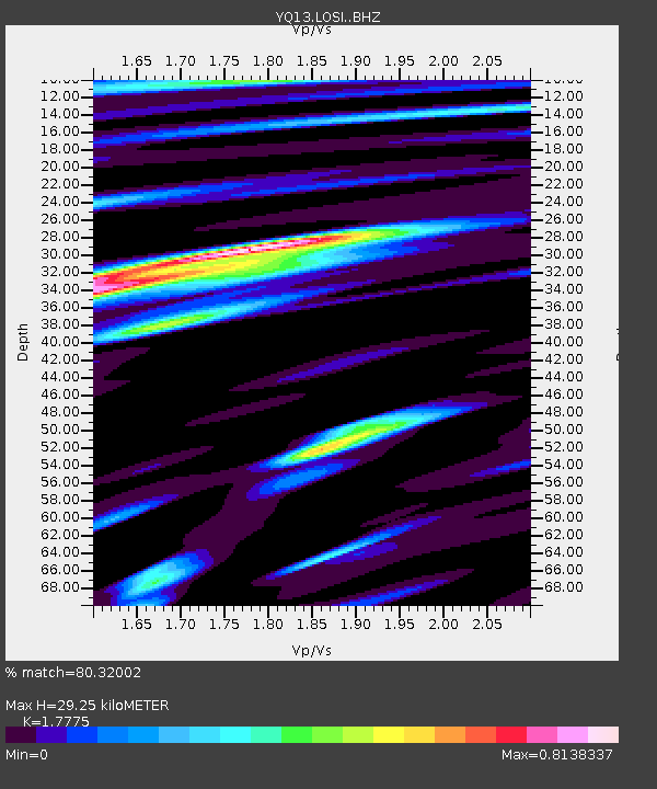
| Estimated Moho Depth: |
29.25 km |
| Estimated Crust Vp/Vs: |
1.78 |
| Assumed Crust Vp: |
6.502 km/s |
| Estimated Crust Vs: |
3.658 km/s |
| Estimated Crust Poisson's Ratio: |
0.27 |
|
| Radial Match: |
80.32002 % |
| Radial Bump: |
400 |
| Transverse Match: |
73.04189 % |
| Transverse Bump: |
400 |
| SOD ConfigId: |
3390531 |
| Insert Time: |
2019-04-15 03:24:15.102 +0000 |
| GWidth: |
2.5 |
| Max Bumps: |
400 |
| Tol: |
0.001 |
|

Signal To Noise
| Channel | StoN | STA | LTA |
| YQ:LOSI: :BHZ:20141120T18:24:54.234983Z | 2.25976 | 1.4592973E-7 | 6.4577534E-8 |
| YQ:LOSI: :BHN:20141120T18:24:54.234983Z | 1.9638885 | 6.903976E-8 | 3.515462E-8 |
| YQ:LOSI: :BHE:20141120T18:24:54.234983Z | 1.5763677 | 5.3341722E-8 | 3.3838376E-8 |
| Arrivals |
| Ps | 3.6 SECOND |
| PpPs | 12 SECOND |
| PsPs/PpSs | 16 SECOND |


