You are here: Home > Network List > UW - Pacific Northwest Regional Seismic Network Stations List
> Station DAVN Chrisman Ranch, Davenport, WA, USA > Earthquake Result Viewer
DAVN Chrisman Ranch, Davenport, WA, USA - Earthquake Result Viewer
| Earthquake location: |
Near Coast Of Chiapas, Mexico |
| Earthquake latitude/longitude: |
14.6/-92.1 |
| Earthquake time(UTC): |
2013/09/07 (250) 00:13:29 GMT |
| Earthquake Depth: |
66 km |
| Earthquake Magnitude: |
6.4 MWW, 6.4 MWB, 6.4 MWC, 6.4 MWW, 6.5 MWC |
| Earthquake Catalog/Contributor: |
NEIC PDE/NEIC COMCAT |
|
| Network: |
UW Pacific Northwest Regional Seismic Network |
| Station: |
DAVN Chrisman Ranch, Davenport, WA, USA |
| Lat/Lon: |
47.80 N/118.27 W |
| Elevation: |
495 m |
|
| Distance: |
39.6 deg |
| Az: |
332.189 deg |
| Baz: |
137.936 deg |
| Ray Param: |
0.07471443 |
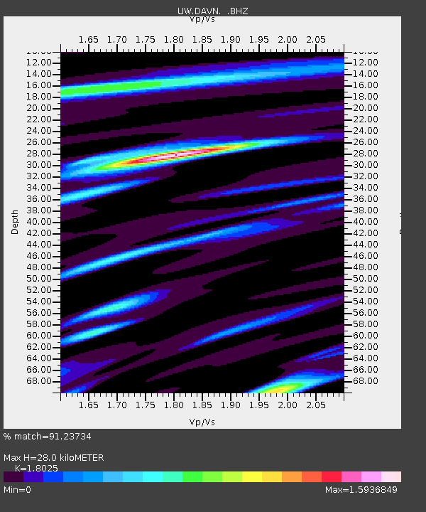
| Estimated Moho Depth: |
28.0 km |
| Estimated Crust Vp/Vs: |
1.80 |
| Assumed Crust Vp: |
6.419 km/s |
| Estimated Crust Vs: |
3.561 km/s |
| Estimated Crust Poisson's Ratio: |
0.28 |
|
| Radial Match: |
91.23734 % |
| Radial Bump: |
341 |
| Transverse Match: |
72.26271 % |
| Transverse Bump: |
400 |
| SOD ConfigId: |
626651 |
| Insert Time: |
2014-04-18 15:12:16.624 +0000 |
| GWidth: |
2.5 |
| Max Bumps: |
400 |
| Tol: |
0.001 |
|
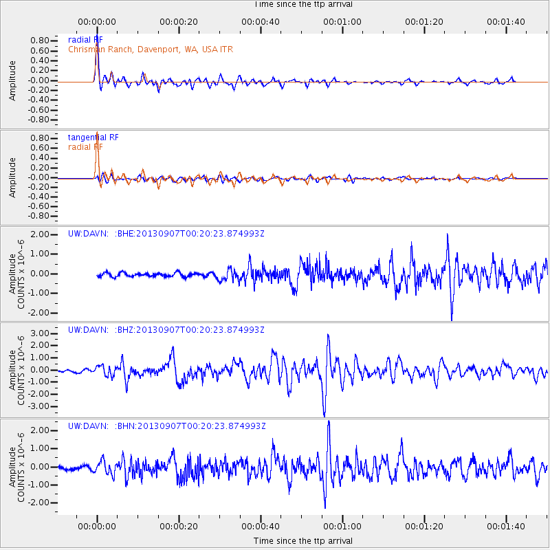
Signal To Noise
| Channel | StoN | STA | LTA |
| UW:DAVN: :BHZ:20130907T00:20:23.874993Z | 3.6879056 | 3.913731E-7 | 1.0612341E-7 |
| UW:DAVN: :BHN:20130907T00:20:23.874993Z | 3.6806197 | 3.584943E-7 | 9.740053E-8 |
| UW:DAVN: :BHE:20130907T00:20:23.874993Z | 2.9403923 | 2.8091543E-7 | 9.553671E-8 |
| Arrivals |
| Ps | 3.8 SECOND |
| PpPs | 11 SECOND |
| PsPs/PpSs | 15 SECOND |


