LON Longmire (broad-band and DWWSSN) - Earthquake Result Viewer
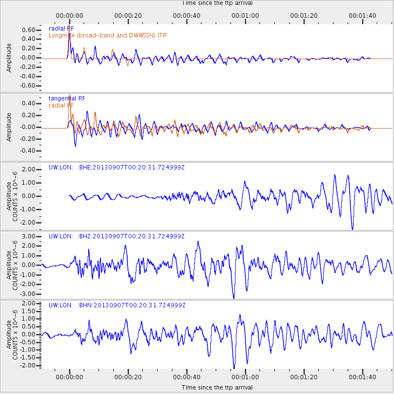
Earthquake location: Near Coast Of Chiapas, Mexico
Earthquake latitude/longitude: 14.6/-92.1
Earthquake time(UTC): 2013/09/07 (250) 00:13:29 GMT
Earthquake Depth: 66 km
Earthquake Magnitude: 6.4 MWW, 6.4 MWB, 6.4 MWC, 6.4 MWW, 6.5 MWC
Earthquake Catalog/Contributor: NEIC PDE/NEIC COMCAT
Network: UW Pacific Northwest Regional Seismic Network
Station: LON Longmire (broad-band and DWWSSN)
Lat/Lon: 46.75 N/121.81 W
Elevation: 850 m
Distance: 40.5 deg
Az: 328.382 deg
Baz: 132.432 deg
Ray Param: 0.07416008
Estimated Moho Depth: 14.0 km
Estimated Crust Vp/Vs: 1.60
Assumed Crust Vp: 6.597 km/s
Estimated Crust Vs: 4.123 km/s
Estimated Crust Poisson's Ratio: 0.18
Radial Match: 91.43447 %
Radial Bump: 400
Transverse Match: 86.78172 %
Transverse Bump: 400
SOD ConfigId: 626651
Insert Time: 2014-04-18 15:12:34.214 +0000
GWidth: 2.5
Max Bumps: 400
Tol: 0.001

Signal To Noise

ChannelStoNSTALTA
UW:LON: :BHZ:20130907T00:20:31.724999Z4.29642775.39721E-71.2562087E-7
UW:LON: :BHN:20130907T00:20:31.724999Z1.8514182.0853918E-71.12637544E-7
UW:LON: :BHE:20130907T00:20:31.724999Z0.768689639.4698734E-81.2319502E-7
Arrivals
Ps1.4 SECOND
PpPs5.1 SECOND
PsPs/PpSs6.5 SECOND