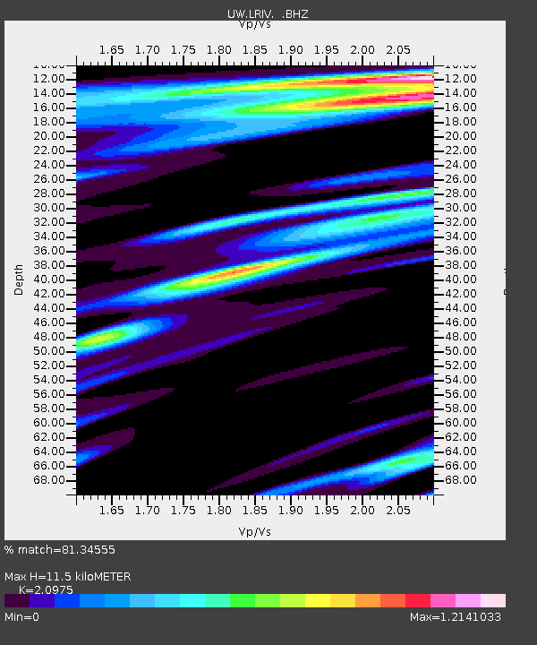
LRIV Port Angeles, WA, USA - Earthquake Result Viewer

Earthquake location: Near Coast Of Chiapas, Mexico
Earthquake latitude/longitude: 14.6/-92.1
Earthquake time(UTC): 2013/09/07 (250) 00:13:29 GMT
Earthquake Depth: 66 km
Earthquake Magnitude: 6.4 MWW, 6.4 MWB, 6.4 MWC, 6.4 MWW, 6.5 MWC
Earthquake Catalog/Contributor: NEIC PDE/NEIC COMCAT
Network: UW Pacific Northwest Regional Seismic Network
Station: LRIV Port Angeles, WA, USA
Lat/Lon: 48.06 N/123.50 W
Elevation: 294 m
Distance: 42.2 deg
Az: 328.692 deg
Baz: 131.42 deg
Ray Param: 0.07310005
Estimated Moho Depth: 11.5 km
Estimated Crust Vp/Vs: 2.10
Assumed Crust Vp: 6.566 km/s
Estimated Crust Vs: 3.13 km/s
Estimated Crust Poisson's Ratio: 0.35
Radial Match: 81.34555 %
Radial Bump: 400
Transverse Match: 82.40831 %
Transverse Bump: 400
SOD ConfigId: 626651
Insert Time: 2014-04-18 15:12:34.569 +0000
GWidth: 2.5
Max Bumps: 400
Tol: 0.001

Signal To Noise

ChannelStoNSTALTA
UW:LRIV: :BHZ:20130907T00:20:45.879998Z3.2032094.8682426E-71.5198017E-7
UW:LRIV: :BHN:20130907T00:20:45.879998Z1.24763432.5806594E-72.0684422E-7
UW:LRIV: :BHE:20130907T00:20:45.879998Z1.17408492.1427081E-71.8250027E-7
Arrivals
Ps2.0 SECOND
PpPs5.1 SECOND
PsPs/PpSs7.2 SECOND