You are here: Home > Network List > YY13 - Exploring extensional tectonics beyond the Ethiopian Rift Stations List
> Station HARO School, Haroo, Ethiopia > Earthquake Result Viewer
HARO School, Haroo, Ethiopia - Earthquake Result Viewer
| Earthquake location: |
Myanmar-India Border Region |
| Earthquake latitude/longitude: |
23.5/93.5 |
| Earthquake time(UTC): |
2014/11/20 (324) 18:14:37 GMT |
| Earthquake Depth: |
48 km |
| Earthquake Magnitude: |
5.6 MWB |
| Earthquake Catalog/Contributor: |
NEIC PDE/NEIC COMCAT |
|
| Network: |
YY Exploring extensional tectonics beyond the Ethiopian Rift |
| Station: |
HARO School, Haroo, Ethiopia |
| Lat/Lon: |
9.85 N/36.31 E |
| Elevation: |
2042 m |
|
| Distance: |
56.1 deg |
| Az: |
266.147 deg |
| Baz: |
68.335 deg |
| Ray Param: |
0.06423256 |
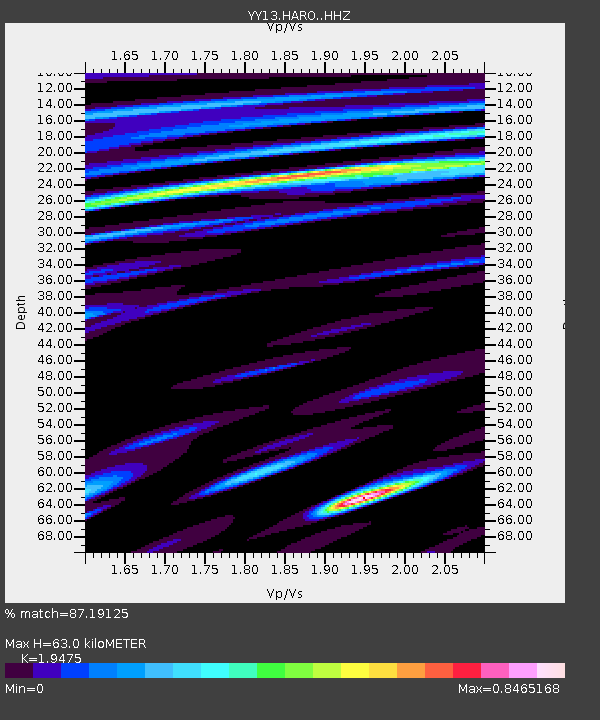
| Estimated Moho Depth: |
63.0 km |
| Estimated Crust Vp/Vs: |
1.95 |
| Assumed Crust Vp: |
6.404 km/s |
| Estimated Crust Vs: |
3.288 km/s |
| Estimated Crust Poisson's Ratio: |
0.32 |
|
| Radial Match: |
87.19125 % |
| Radial Bump: |
400 |
| Transverse Match: |
68.3898 % |
| Transverse Bump: |
400 |
| SOD ConfigId: |
3390531 |
| Insert Time: |
2019-04-15 03:24:27.245 +0000 |
| GWidth: |
2.5 |
| Max Bumps: |
400 |
| Tol: |
0.001 |
|

Signal To Noise
| Channel | StoN | STA | LTA |
| YY:HARO: :HHZ:20141120T18:23:41.538999Z | 4.5782986 | 1.9958712E-7 | 4.359417E-8 |
| YY:HARO: :HHN:20141120T18:23:41.538999Z | 2.0909002 | 7.2669465E-8 | 3.475511E-8 |
| YY:HARO: :HHE:20141120T18:23:41.538999Z | 3.3380523 | 1.16311625E-7 | 3.484416E-8 |
| Arrivals |
| Ps | 9.8 SECOND |
| PpPs | 28 SECOND |
| PsPs/PpSs | 37 SECOND |


