You are here: Home > Network List > YY13 - Exploring extensional tectonics beyond the Ethiopian Rift Stations List
> Station SERE Military Camp, Saraba, Ethiopia > Earthquake Result Viewer
SERE Military Camp, Saraba, Ethiopia - Earthquake Result Viewer
| Earthquake location: |
Myanmar-India Border Region |
| Earthquake latitude/longitude: |
23.5/93.5 |
| Earthquake time(UTC): |
2014/11/20 (324) 18:14:37 GMT |
| Earthquake Depth: |
48 km |
| Earthquake Magnitude: |
5.6 MWB |
| Earthquake Catalog/Contributor: |
NEIC PDE/NEIC COMCAT |
|
| Network: |
YY Exploring extensional tectonics beyond the Ethiopian Rift |
| Station: |
SERE Military Camp, Saraba, Ethiopia |
| Lat/Lon: |
12.51 N/37.03 E |
| Elevation: |
2152 m |
|
| Distance: |
54.5 deg |
| Az: |
268.853 deg |
| Baz: |
70.013 deg |
| Ray Param: |
0.06528358 |
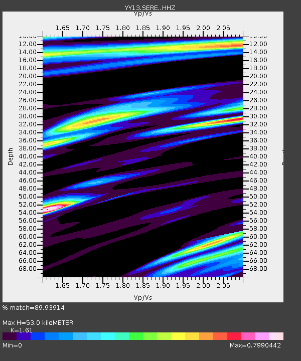
| Estimated Moho Depth: |
53.0 km |
| Estimated Crust Vp/Vs: |
1.61 |
| Assumed Crust Vp: |
6.464 km/s |
| Estimated Crust Vs: |
4.015 km/s |
| Estimated Crust Poisson's Ratio: |
0.19 |
|
| Radial Match: |
89.93914 % |
| Radial Bump: |
400 |
| Transverse Match: |
80.88826 % |
| Transverse Bump: |
400 |
| SOD ConfigId: |
3390531 |
| Insert Time: |
2019-04-15 03:24:30.898 +0000 |
| GWidth: |
2.5 |
| Max Bumps: |
400 |
| Tol: |
0.001 |
|

Signal To Noise
| Channel | StoN | STA | LTA |
| YY:SERE: :HHZ:20141120T18:23:30.038999Z | 6.184862 | 3.1031922E-7 | 5.017399E-8 |
| YY:SERE: :HHN:20141120T18:23:30.038999Z | 1.5066491 | 8.947497E-8 | 5.9386736E-8 |
| YY:SERE: :HHE:20141120T18:23:30.038999Z | 1.666724 | 9.6936E-8 | 5.81596E-8 |
| Arrivals |
| Ps | 5.3 SECOND |
| PpPs | 20 SECOND |
| PsPs/PpSs | 25 SECOND |


