You are here: Home > Network List > WY - Yellowstone Wyoming Seismic Network Stations List
> Station YPP Pitchstone Plateau, YNP, WY, USA > Earthquake Result Viewer
YPP Pitchstone Plateau, YNP, WY, USA - Earthquake Result Viewer
| Earthquake location: |
Near Coast Of Chiapas, Mexico |
| Earthquake latitude/longitude: |
14.6/-92.1 |
| Earthquake time(UTC): |
2013/09/07 (250) 00:13:29 GMT |
| Earthquake Depth: |
66 km |
| Earthquake Magnitude: |
6.4 MWW, 6.4 MWB, 6.4 MWC, 6.4 MWW, 6.5 MWC |
| Earthquake Catalog/Contributor: |
NEIC PDE/NEIC COMCAT |
|
| Network: |
WY Yellowstone Wyoming Seismic Network |
| Station: |
YPP Pitchstone Plateau, YNP, WY, USA |
| Lat/Lon: |
44.27 N/110.80 W |
| Elevation: |
2707 m |
|
| Distance: |
33.6 deg |
| Az: |
335.412 deg |
| Baz: |
145.894 deg |
| Ray Param: |
0.07797942 |
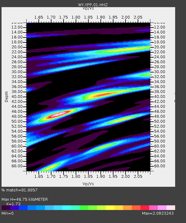
| Estimated Moho Depth: |
46.75 km |
| Estimated Crust Vp/Vs: |
1.73 |
| Assumed Crust Vp: |
6.35 km/s |
| Estimated Crust Vs: |
3.671 km/s |
| Estimated Crust Poisson's Ratio: |
0.25 |
|
| Radial Match: |
81.8857 % |
| Radial Bump: |
400 |
| Transverse Match: |
76.7107 % |
| Transverse Bump: |
400 |
| SOD ConfigId: |
626651 |
| Insert Time: |
2014-04-18 15:14:08.586 +0000 |
| GWidth: |
2.5 |
| Max Bumps: |
400 |
| Tol: |
0.001 |
|
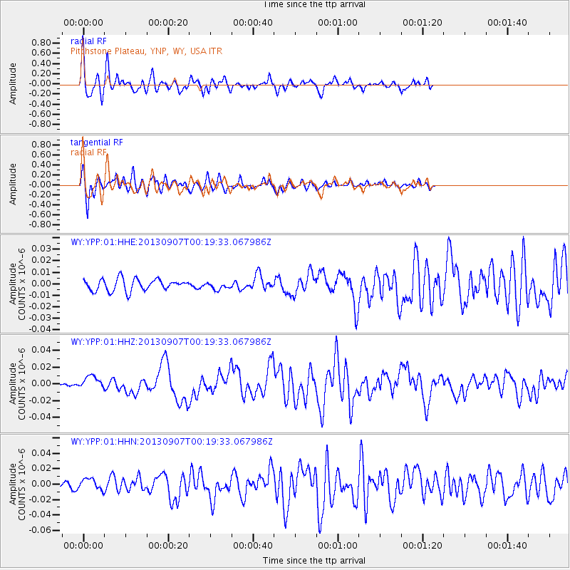
Signal To Noise
| Channel | StoN | STA | LTA |
| WY:YPP:01:HHZ:20130907T00:19:33.067986Z | 2.4838948 | 7.709889E-9 | 3.1039513E-9 |
| WY:YPP:01:HHN:20130907T00:19:33.067986Z | 1.7683744 | 7.3095445E-9 | 4.1334824E-9 |
| WY:YPP:01:HHE:20130907T00:19:33.067986Z | 0.6090455 | 3.142914E-9 | 5.1603926E-9 |
| Arrivals |
| Ps | 5.8 SECOND |
| PpPs | 19 SECOND |
| PsPs/PpSs | 24 SECOND |


