You are here: Home > Network List > GO - National Seismic Network of Georgia Stations List
> Station TBLG Delisi, Georgia > Earthquake Result Viewer
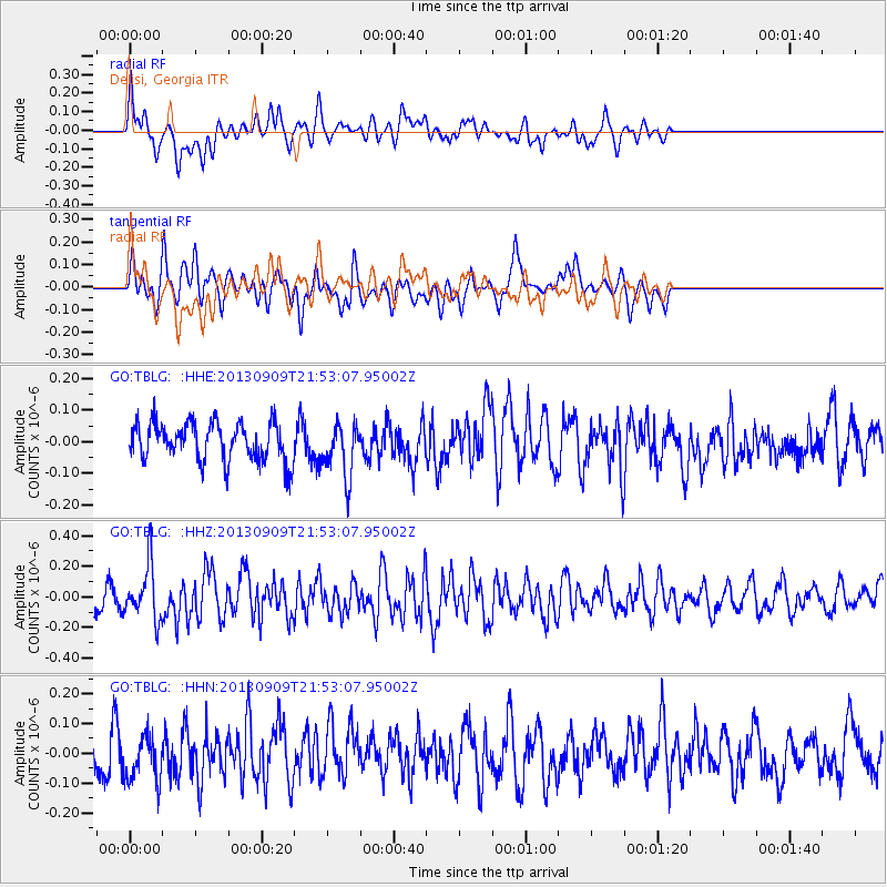
TBLG Delisi, Georgia - Earthquake Result Viewer
*The percent match for this event was below the threshold and hence no stack was calculated.
| Earthquake location: |
Minahassa Peninsula, Sulawesi |
| Earthquake latitude/longitude: |
1.4/122.2 |
| Earthquake time(UTC): |
2013/09/09 (252) 21:41:33 GMT |
| Earthquake Depth: |
22 km |
| Earthquake Magnitude: |
5.6 MWW, 5.4 MWB, 5.6 MWW, 5.6 MWC |
| Earthquake Catalog/Contributor: |
NEIC PDE/NEIC COMCAT |
|
| Network: |
GO National Seismic Network of Georgia |
| Station: |
TBLG Delisi, Georgia |
| Lat/Lon: |
41.73 N/44.74 E |
| Elevation: |
510 m |
|
| Distance: |
79.7 deg |
| Az: |
312.049 deg |
| Baz: |
97.341 deg |
| Ray Param: |
$rayparam |
*The percent match for this event was below the threshold and hence was not used in the summary stack. |
|
| Radial Match: |
66.89881 % |
| Radial Bump: |
400 |
| Transverse Match: |
65.13791 % |
| Transverse Bump: |
400 |
| SOD ConfigId: |
626651 |
| Insert Time: |
2014-04-18 15:19:06.279 +0000 |
| GWidth: |
2.5 |
| Max Bumps: |
400 |
| Tol: |
0.001 |
|
Signal To Noise
| Channel | StoN | STA | LTA |
| GO:TBLG: :HHZ:20130909T21:53:07.95002Z | 2.5114763 | 1.7574388E-7 | 6.997632E-8 |
| GO:TBLG: :HHN:20130909T21:53:07.95002Z | 1.6307436 | 8.075793E-8 | 4.952215E-8 |
| GO:TBLG: :HHE:20130909T21:53:07.95002Z | 1.4196533 | 8.564733E-8 | 6.0329754E-8 |
| Arrivals |
| Ps | |
| PpPs | |
| PsPs/PpSs | |


