You are here: Home > Network List > TJ - Tajikistan National Seismic Network Stations List
> Station GARM Garm, Tajikistan > Earthquake Result Viewer
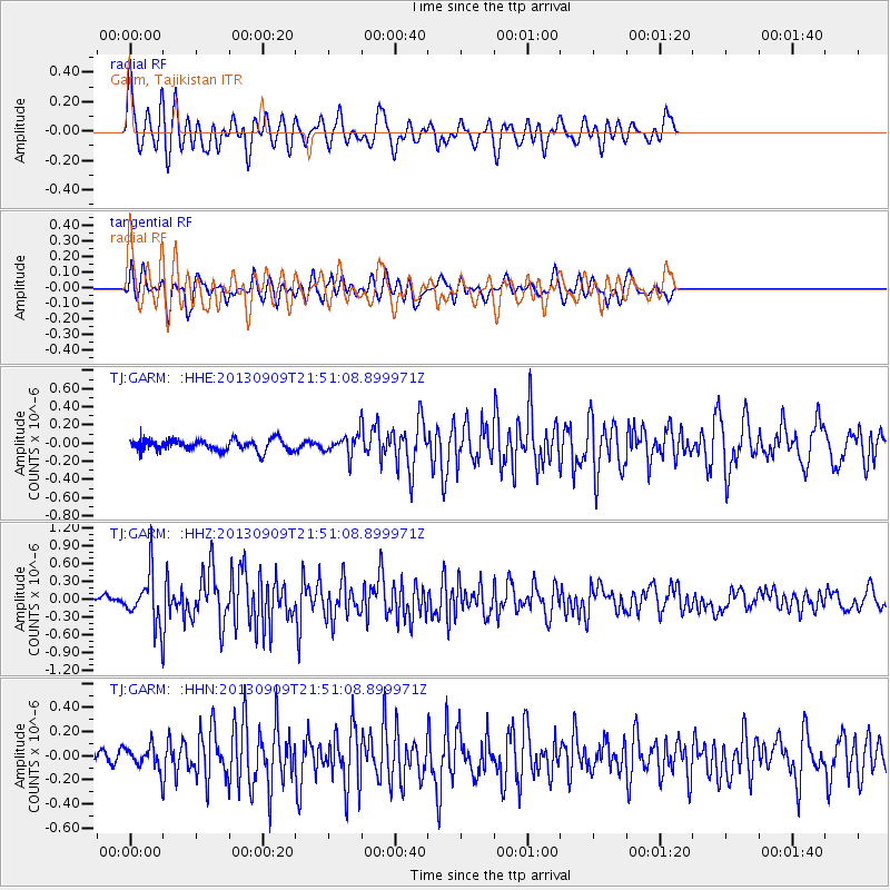
GARM Garm, Tajikistan - Earthquake Result Viewer
*The percent match for this event was below the threshold and hence no stack was calculated.
| Earthquake location: |
Minahassa Peninsula, Sulawesi |
| Earthquake latitude/longitude: |
1.4/122.2 |
| Earthquake time(UTC): |
2013/09/09 (252) 21:41:33 GMT |
| Earthquake Depth: |
22 km |
| Earthquake Magnitude: |
5.6 MWW, 5.4 MWB, 5.6 MWW, 5.6 MWC |
| Earthquake Catalog/Contributor: |
NEIC PDE/NEIC COMCAT |
|
| Network: |
TJ Tajikistan National Seismic Network |
| Station: |
GARM Garm, Tajikistan |
| Lat/Lon: |
39.00 N/70.32 E |
| Elevation: |
1305 m |
|
| Distance: |
60.3 deg |
| Az: |
315.085 deg |
| Baz: |
115.061 deg |
| Ray Param: |
$rayparam |
*The percent match for this event was below the threshold and hence was not used in the summary stack. |
|
| Radial Match: |
79.756744 % |
| Radial Bump: |
400 |
| Transverse Match: |
68.351105 % |
| Transverse Bump: |
400 |
| SOD ConfigId: |
626651 |
| Insert Time: |
2014-04-18 15:24:33.154 +0000 |
| GWidth: |
2.5 |
| Max Bumps: |
400 |
| Tol: |
0.001 |
|
Signal To Noise
| Channel | StoN | STA | LTA |
| TJ:GARM: :HHZ:20130909T21:51:08.899971Z | 4.4841094 | 4.055703E-7 | 9.0446115E-8 |
| TJ:GARM: :HHN:20130909T21:51:08.899971Z | 1.3873936 | 8.7231E-8 | 6.2874015E-8 |
| TJ:GARM: :HHE:20130909T21:51:08.899971Z | 1.7234704 | 1.0492639E-7 | 6.088088E-8 |
| Arrivals |
| Ps | |
| PpPs | |
| PsPs/PpSs | |


