You are here: Home > Network List > CI - Caltech Regional Seismic Network Stations List
> Station TIN Tinemaha, California, USA > Earthquake Result Viewer
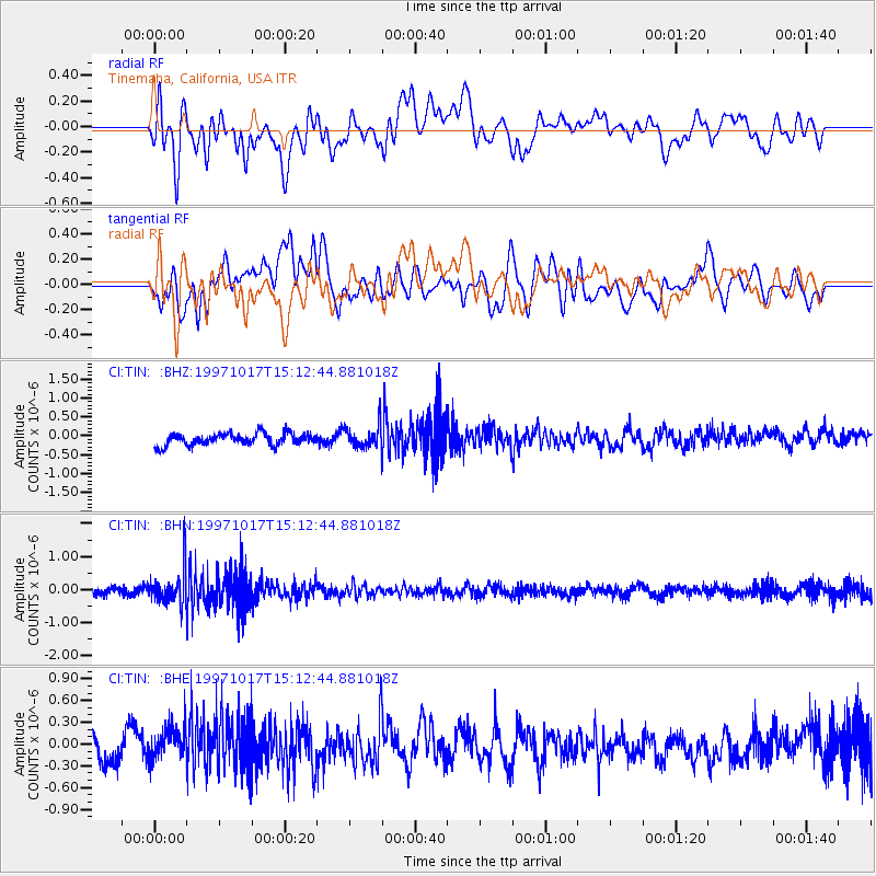
TIN Tinemaha, California, USA - Earthquake Result Viewer
*The percent match for this event was below the threshold and hence no stack was calculated.
| Earthquake location: |
Fiji Islands Region |
| Earthquake latitude/longitude: |
-20.9/-178.8 |
| Earthquake time(UTC): |
1997/10/17 (290) 15:02:00 GMT |
| Earthquake Depth: |
579 km |
| Earthquake Magnitude: |
5.3 MB, 6.0 UNKNOWN, 6.0 MW |
| Earthquake Catalog/Contributor: |
WHDF/NEIC |
|
| Network: |
CI Caltech Regional Seismic Network |
| Station: |
TIN Tinemaha, California, USA |
| Lat/Lon: |
37.05 N/118.23 W |
| Elevation: |
1164 m |
|
| Distance: |
81.1 deg |
| Az: |
44.87 deg |
| Baz: |
235.549 deg |
| Ray Param: |
$rayparam |
*The percent match for this event was below the threshold and hence was not used in the summary stack. |
|
| Radial Match: |
54.333565 % |
| Radial Bump: |
400 |
| Transverse Match: |
44.544014 % |
| Transverse Bump: |
400 |
| SOD ConfigId: |
4480 |
| Insert Time: |
2010-02-25 20:52:08.282 +0000 |
| GWidth: |
2.5 |
| Max Bumps: |
400 |
| Tol: |
0.001 |
|
Signal To Noise
| Channel | StoN | STA | LTA |
| CI:TIN: :BHN:19971017T15:12:44.881018Z | 4.4181166 | 5.234071E-7 | 1.1846838E-7 |
| CI:TIN: :BHE:19971017T15:12:44.881018Z | 1.4121096 | 2.6247042E-7 | 1.8587114E-7 |
| CI:TIN: :BHZ:19971017T15:12:44.881018Z | 1.7341851 | 2.692398E-7 | 1.5525436E-7 |
| Arrivals |
| Ps | |
| PpPs | |
| PsPs/PpSs | |


