You are here: Home > Network List > XJ13 - CRAFTI Stations List
> Station LN14 Matela PS > Earthquake Result Viewer
LN14 Matela PS - Earthquake Result Viewer
| Earthquake location: |
Philippine Islands Region |
| Earthquake latitude/longitude: |
20.7/120.0 |
| Earthquake time(UTC): |
2014/11/21 (325) 03:29:12 GMT |
| Earthquake Depth: |
10 km |
| Earthquake Magnitude: |
5.9 MWP |
| Earthquake Catalog/Contributor: |
NEIC PDE/NEIC COMCAT |
|
| Network: |
XJ CRAFTI |
| Station: |
LN14 Matela PS |
| Lat/Lon: |
2.44 S/36.42 E |
| Elevation: |
1631 m |
|
| Distance: |
84.9 deg |
| Az: |
265.478 deg |
| Baz: |
69.111 deg |
| Ray Param: |
0.045156077 |
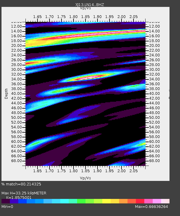
| Estimated Moho Depth: |
33.25 km |
| Estimated Crust Vp/Vs: |
1.86 |
| Assumed Crust Vp: |
6.601 km/s |
| Estimated Crust Vs: |
3.554 km/s |
| Estimated Crust Poisson's Ratio: |
0.30 |
|
| Radial Match: |
80.214325 % |
| Radial Bump: |
400 |
| Transverse Match: |
74.772316 % |
| Transverse Bump: |
400 |
| SOD ConfigId: |
3390531 |
| Insert Time: |
2019-04-15 03:29:46.416 +0000 |
| GWidth: |
2.5 |
| Max Bumps: |
400 |
| Tol: |
0.001 |
|

Signal To Noise
| Channel | StoN | STA | LTA |
| XJ:LN14: :BHZ:20141121T03:41:16.160007Z | 3.3508825 | 2.5870594E-7 | 7.7205314E-8 |
| XJ:LN14: :BHN:20141121T03:41:16.160007Z | 0.9476133 | 3.3397484E-8 | 3.524379E-8 |
| XJ:LN14: :BHE:20141121T03:41:16.160007Z | 2.2190094 | 9.978567E-8 | 4.496857E-8 |
| Arrivals |
| Ps | 4.4 SECOND |
| PpPs | 14 SECOND |
| PsPs/PpSs | 18 SECOND |


