You are here: Home > Network List > YY13 - Exploring extensional tectonics beyond the Ethiopian Rift Stations List
> Station HARO School, Haroo, Ethiopia > Earthquake Result Viewer
HARO School, Haroo, Ethiopia - Earthquake Result Viewer
| Earthquake location: |
Philippine Islands Region |
| Earthquake latitude/longitude: |
20.7/120.0 |
| Earthquake time(UTC): |
2014/11/21 (325) 03:29:12 GMT |
| Earthquake Depth: |
10 km |
| Earthquake Magnitude: |
5.9 MWP |
| Earthquake Catalog/Contributor: |
NEIC PDE/NEIC COMCAT |
|
| Network: |
YY Exploring extensional tectonics beyond the Ethiopian Rift |
| Station: |
HARO School, Haroo, Ethiopia |
| Lat/Lon: |
9.85 N/36.31 E |
| Elevation: |
2042 m |
|
| Distance: |
80.8 deg |
| Az: |
277.06 deg |
| Baz: |
70.555 deg |
| Ray Param: |
0.048051547 |
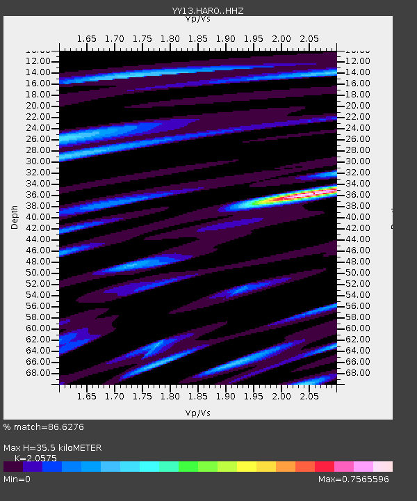
| Estimated Moho Depth: |
35.5 km |
| Estimated Crust Vp/Vs: |
2.06 |
| Assumed Crust Vp: |
6.404 km/s |
| Estimated Crust Vs: |
3.113 km/s |
| Estimated Crust Poisson's Ratio: |
0.35 |
|
| Radial Match: |
86.6276 % |
| Radial Bump: |
400 |
| Transverse Match: |
60.119946 % |
| Transverse Bump: |
400 |
| SOD ConfigId: |
3390531 |
| Insert Time: |
2019-04-15 03:30:59.281 +0000 |
| GWidth: |
2.5 |
| Max Bumps: |
400 |
| Tol: |
0.001 |
|

Signal To Noise
| Channel | StoN | STA | LTA |
| YY:HARO: :HHZ:20141121T03:40:54.949009Z | 2.4295373 | 1.2575424E-7 | 5.1760573E-8 |
| YY:HARO: :HHN:20141121T03:40:54.949009Z | 0.7410778 | 4.1607525E-8 | 5.6144614E-8 |
| YY:HARO: :HHE:20141121T03:40:54.949009Z | 1.5564362 | 8.445794E-8 | 5.426367E-8 |
| Arrivals |
| Ps | 6.0 SECOND |
| PpPs | 17 SECOND |
| PsPs/PpSs | 23 SECOND |


