You are here: Home > Network List > PF - Volcanologic Network of Piton de Fournaise-OVPF Stations List
> Station HIM cratere Himiltrude > Earthquake Result Viewer
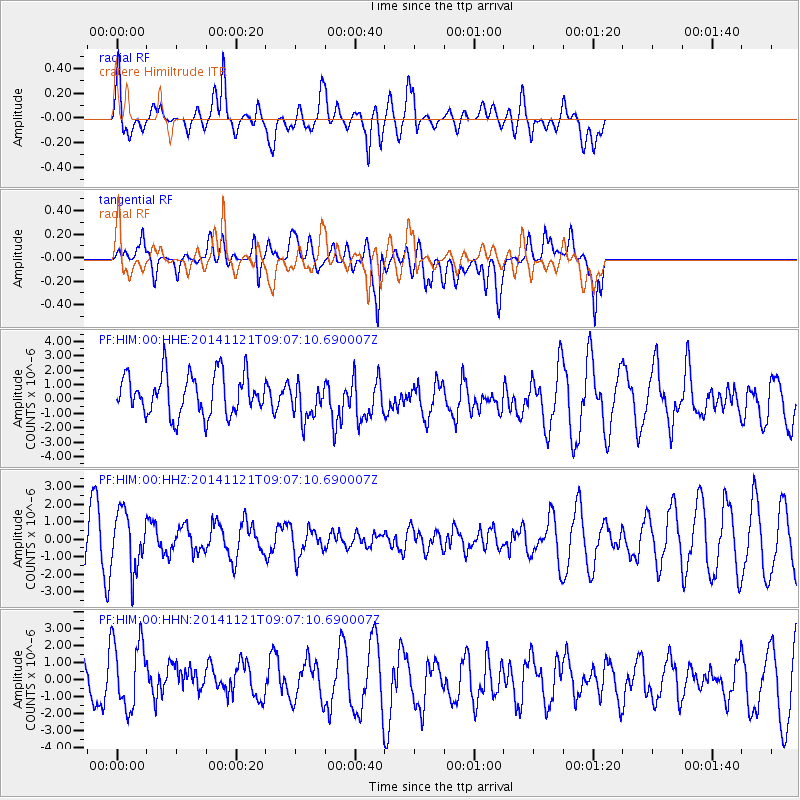
HIM cratere Himiltrude - Earthquake Result Viewer
*The percent match for this event was below the threshold and hence no stack was calculated.
| Earthquake location: |
Afghanistan-Tajikistan Bord Reg. |
| Earthquake latitude/longitude: |
36.5/71.0 |
| Earthquake time(UTC): |
2014/11/21 (325) 08:58:04 GMT |
| Earthquake Depth: |
234 km |
| Earthquake Magnitude: |
5.2 MW, 5.2 mb |
| Earthquake Catalog/Contributor: |
ISC/ISC |
|
| Network: |
PF Volcanologic Network of Piton de Fournaise-OVPF |
| Station: |
HIM cratere Himiltrude |
| Lat/Lon: |
21.21 S/55.72 E |
| Elevation: |
1958 m |
|
| Distance: |
59.2 deg |
| Az: |
196.662 deg |
| Baz: |
14.331 deg |
| Ray Param: |
$rayparam |
*The percent match for this event was below the threshold and hence was not used in the summary stack. |
|
| Radial Match: |
79.60308 % |
| Radial Bump: |
400 |
| Transverse Match: |
46.617237 % |
| Transverse Bump: |
400 |
| SOD ConfigId: |
3390531 |
| Insert Time: |
2019-04-15 03:34:33.698 +0000 |
| GWidth: |
2.5 |
| Max Bumps: |
400 |
| Tol: |
0.001 |
|
Signal To Noise
| Channel | StoN | STA | LTA |
| PF:HIM:00:HHZ:20141121T09:07:10.690007Z | 1.7704221 | 1.6518486E-6 | 9.3302526E-7 |
| PF:HIM:00:HHN:20141121T09:07:10.690007Z | 1.5552875 | 2.1213632E-6 | 1.3639685E-6 |
| PF:HIM:00:HHE:20141121T09:07:10.690007Z | 0.9353507 | 1.308945E-6 | 1.3994163E-6 |
| Arrivals |
| Ps | |
| PpPs | |
| PsPs/PpSs | |


