You are here: Home > Network List > TA - USArray Transportable Network (new EarthScope stations) Stations List
> Station 121A Cookes Peak, Deming, NM, USA > Earthquake Result Viewer
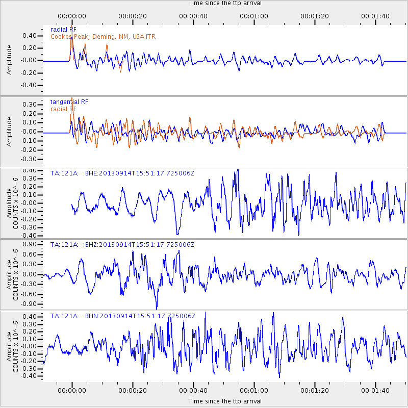
121A Cookes Peak, Deming, NM, USA - Earthquake Result Viewer
*The percent match for this event was below the threshold and hence no stack was calculated.
| Earthquake location: |
Andreanof Islands, Aleutian Is. |
| Earthquake latitude/longitude: |
51.4/-174.6 |
| Earthquake time(UTC): |
2013/09/14 (257) 15:42:46 GMT |
| Earthquake Depth: |
20 km |
| Earthquake Magnitude: |
5.9 MWW, 5.4 MI, 5.8 MWB, 5.9 MWC, 6.0 MWC |
| Earthquake Catalog/Contributor: |
NEIC PDE/NEIC COMCAT |
|
| Network: |
TA USArray Transportable Network (new EarthScope stations) |
| Station: |
121A Cookes Peak, Deming, NM, USA |
| Lat/Lon: |
32.53 N/107.79 W |
| Elevation: |
1652 m |
|
| Distance: |
51.3 deg |
| Az: |
84.411 deg |
| Baz: |
312.486 deg |
| Ray Param: |
$rayparam |
*The percent match for this event was below the threshold and hence was not used in the summary stack. |
|
| Radial Match: |
64.62699 % |
| Radial Bump: |
400 |
| Transverse Match: |
48.081215 % |
| Transverse Bump: |
400 |
| SOD ConfigId: |
626651 |
| Insert Time: |
2014-04-18 16:23:54.566 +0000 |
| GWidth: |
2.5 |
| Max Bumps: |
400 |
| Tol: |
0.001 |
|
Signal To Noise
| Channel | StoN | STA | LTA |
| TA:121A: :BHZ:20130914T15:51:17.725006Z | 3.551877 | 2.5043204E-7 | 7.050696E-8 |
| TA:121A: :BHN:20130914T15:51:17.725006Z | 0.61339957 | 5.615631E-8 | 9.154932E-8 |
| TA:121A: :BHE:20130914T15:51:17.725006Z | 1.8961563 | 1.6205937E-7 | 8.5467306E-8 |
| Arrivals |
| Ps | |
| PpPs | |
| PsPs/PpSs | |


