You are here: Home > Network List > TA - USArray Transportable Network (new EarthScope stations) Stations List
> Station G59A Clarenceville, QC, USA > Earthquake Result Viewer
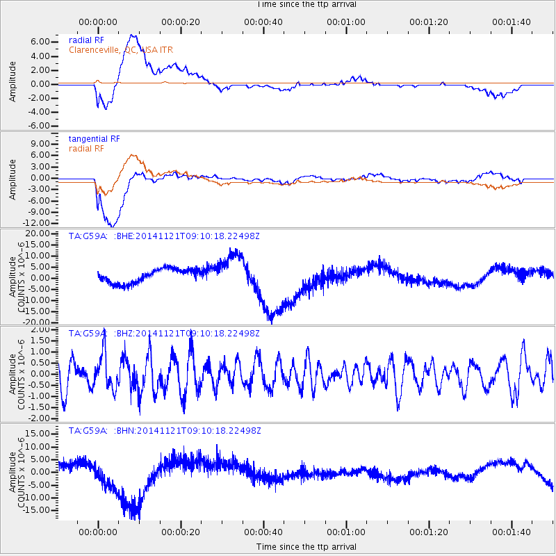
G59A Clarenceville, QC, USA - Earthquake Result Viewer
*The percent match for this event was below the threshold and hence no stack was calculated.
| Earthquake location: |
Afghanistan-Tajikistan Bord Reg. |
| Earthquake latitude/longitude: |
36.5/71.0 |
| Earthquake time(UTC): |
2014/11/21 (325) 08:58:04 GMT |
| Earthquake Depth: |
234 km |
| Earthquake Magnitude: |
5.2 MW, 5.2 mb |
| Earthquake Catalog/Contributor: |
ISC/ISC |
|
| Network: |
TA USArray Transportable Network (new EarthScope stations) |
| Station: |
G59A Clarenceville, QC, USA |
| Lat/Lon: |
45.08 N/73.18 W |
| Elevation: |
36 m |
|
| Distance: |
92.6 deg |
| Az: |
335.496 deg |
| Baz: |
28.136 deg |
| Ray Param: |
$rayparam |
*The percent match for this event was below the threshold and hence was not used in the summary stack. |
|
| Radial Match: |
58.997513 % |
| Radial Bump: |
400 |
| Transverse Match: |
72.56044 % |
| Transverse Bump: |
400 |
| SOD ConfigId: |
3390531 |
| Insert Time: |
2019-04-15 03:35:10.014 +0000 |
| GWidth: |
2.5 |
| Max Bumps: |
400 |
| Tol: |
0.001 |
|
Signal To Noise
| Channel | StoN | STA | LTA |
| TA:G59A: :BHZ:20141121T09:10:18.22498Z | 1.171479 | 8.176133E-7 | 6.9793253E-7 |
| TA:G59A: :BHN:20141121T09:10:18.22498Z | 3.7552223 | 6.8944564E-6 | 1.835965E-6 |
| TA:G59A: :BHE:20141121T09:10:18.22498Z | 2.5751333 | 7.979331E-6 | 3.0986087E-6 |
| Arrivals |
| Ps | |
| PpPs | |
| PsPs/PpSs | |


