You are here: Home > Network List > US - United States National Seismic Network Stations List
> Station EGMT Eagleton, Montana, USA > Earthquake Result Viewer
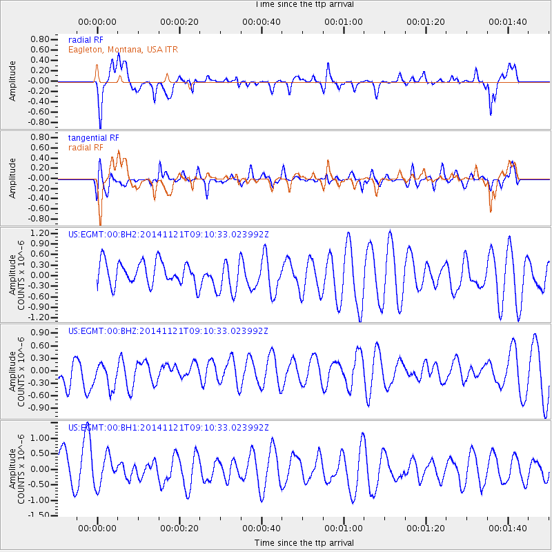
EGMT Eagleton, Montana, USA - Earthquake Result Viewer
*The percent match for this event was below the threshold and hence no stack was calculated.
| Earthquake location: |
Afghanistan-Tajikistan Bord Reg. |
| Earthquake latitude/longitude: |
36.5/71.0 |
| Earthquake time(UTC): |
2014/11/21 (325) 08:58:04 GMT |
| Earthquake Depth: |
234 km |
| Earthquake Magnitude: |
5.2 MW, 5.2 mb |
| Earthquake Catalog/Contributor: |
ISC/ISC |
|
| Network: |
US United States National Seismic Network |
| Station: |
EGMT Eagleton, Montana, USA |
| Lat/Lon: |
48.02 N/109.75 W |
| Elevation: |
1055 m |
|
| Distance: |
95.8 deg |
| Az: |
0.528 deg |
| Baz: |
359.367 deg |
| Ray Param: |
$rayparam |
*The percent match for this event was below the threshold and hence was not used in the summary stack. |
|
| Radial Match: |
57.584934 % |
| Radial Bump: |
400 |
| Transverse Match: |
30.420773 % |
| Transverse Bump: |
400 |
| SOD ConfigId: |
3390531 |
| Insert Time: |
2019-04-15 03:35:35.549 +0000 |
| GWidth: |
2.5 |
| Max Bumps: |
400 |
| Tol: |
0.001 |
|
Signal To Noise
| Channel | StoN | STA | LTA |
| US:EGMT:00:BHZ:20141121T09:10:33.023992Z | 1.3803637 | 3.6488296E-7 | 2.6433827E-7 |
| US:EGMT:00:BH1:20141121T09:10:33.023992Z | 0.9681801 | 4.853898E-7 | 5.0134247E-7 |
| US:EGMT:00:BH2:20141121T09:10:33.023992Z | 1.4958898 | 4.871209E-7 | 3.2563955E-7 |
| Arrivals |
| Ps | |
| PpPs | |
| PsPs/PpSs | |


