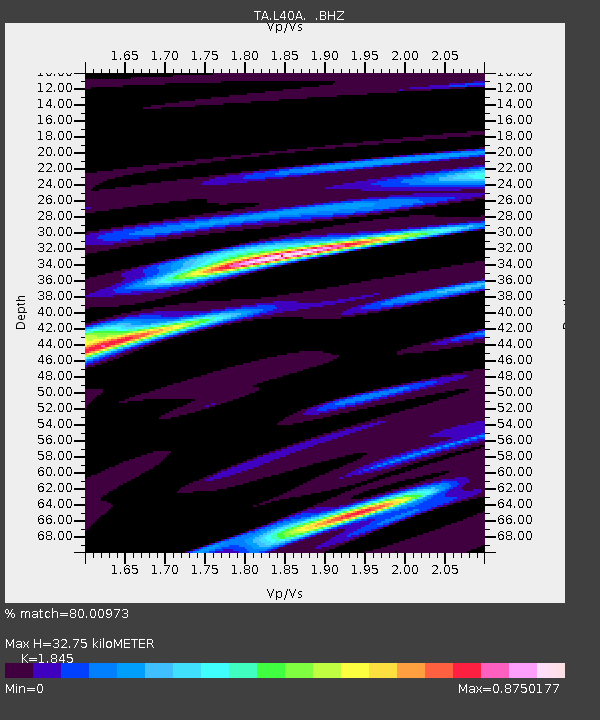
L40A Anamosa, IA, USA - Earthquake Result Viewer
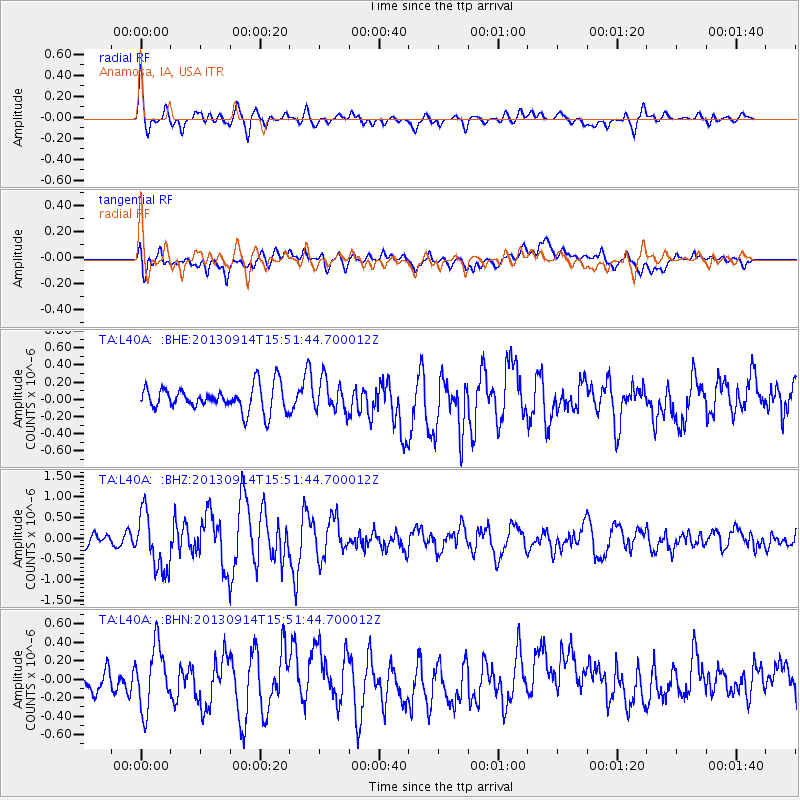
Earthquake location: Andreanof Islands, Aleutian Is.
Earthquake latitude/longitude: 51.4/-174.6
Earthquake time(UTC): 2013/09/14 (257) 15:42:46 GMT
Earthquake Depth: 20 km
Earthquake Magnitude: 5.9 MWW, 5.4 MI, 5.8 MWB, 5.9 MWC, 6.0 MWC
Earthquake Catalog/Contributor: NEIC PDE/NEIC COMCAT
Network: TA USArray Transportable Network (new EarthScope stations)
Station: L40A Anamosa, IA, USA
Lat/Lon: 42.06 N/91.22 W
Elevation: 242 m
Distance: 55.0 deg
Az: 64.605 deg
Baz: 310.595 deg
Ray Param: 0.065079354
Estimated Moho Depth: 32.75 km
Estimated Crust Vp/Vs: 1.85
Assumed Crust Vp: 6.53 km/s
Estimated Crust Vs: 3.54 km/s
Estimated Crust Poisson's Ratio: 0.29
Radial Match: 80.00973 %
Radial Bump: 400
Transverse Match: 50.14972 %
Transverse Bump: 400
SOD ConfigId: 626651
Insert Time: 2014-04-18 16:31:08.129 +0000
GWidth: 2.5
Max Bumps: 400
Tol: 0.001

Signal To Noise

ChannelStoNSTALTA
TA:L40A: :BHZ:20130914T15:51:44.700012Z3.3050416.850821E-72.07284E-7
TA:L40A: :BHN:20130914T15:51:44.700012Z1.89848473.3715656E-71.7759245E-7
TA:L40A: :BHE:20130914T15:51:44.700012Z1.2431141.7956464E-71.4444744E-7
Arrivals
Ps4.5 SECOND
PpPs14 SECOND
PsPs/PpSs18 SECOND