You are here: Home > Network List > ND - New CaleDonia Broadband Seismic Network Stations List
> Station KOUNC Koumac, New Caledonia > Earthquake Result Viewer
KOUNC Koumac, New Caledonia - Earthquake Result Viewer
| Earthquake location: |
Northern Molucca Sea |
| Earthquake latitude/longitude: |
2.3/127.1 |
| Earthquake time(UTC): |
2014/11/21 (325) 10:10:19 GMT |
| Earthquake Depth: |
38 km |
| Earthquake Magnitude: |
6.5 MWC, 6.8 MI, 6.9 MI |
| Earthquake Catalog/Contributor: |
NEIC PDE/NEIC COMCAT |
|
| Network: |
ND New CaleDonia Broadband Seismic Network |
| Station: |
KOUNC Koumac, New Caledonia |
| Lat/Lon: |
20.55 S/164.29 E |
| Elevation: |
88 m |
|
| Distance: |
43.0 deg |
| Az: |
123.701 deg |
| Baz: |
297.493 deg |
| Ray Param: |
0.07277075 |
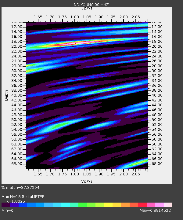
| Estimated Moho Depth: |
18.5 km |
| Estimated Crust Vp/Vs: |
1.80 |
| Assumed Crust Vp: |
5.14 km/s |
| Estimated Crust Vs: |
2.852 km/s |
| Estimated Crust Poisson's Ratio: |
0.28 |
|
| Radial Match: |
87.37204 % |
| Radial Bump: |
400 |
| Transverse Match: |
79.34712 % |
| Transverse Bump: |
400 |
| SOD ConfigId: |
3390531 |
| Insert Time: |
2019-04-15 03:38:59.962 +0000 |
| GWidth: |
2.5 |
| Max Bumps: |
400 |
| Tol: |
0.001 |
|
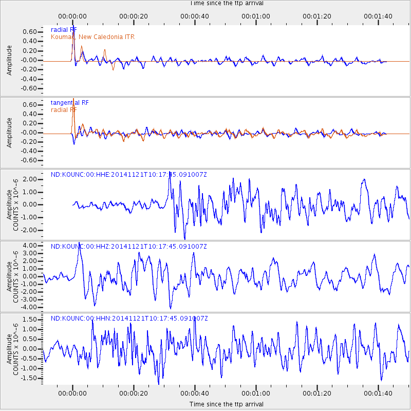
Signal To Noise
| Channel | StoN | STA | LTA |
| ND:KOUNC:00:HHZ:20141121T10:17:45.091007Z | 7.6281476 | 2.0956625E-6 | 2.7472757E-7 |
| ND:KOUNC:00:HHN:20141121T10:17:45.091007Z | 1.2278961 | 3.4877945E-7 | 2.840464E-7 |
| ND:KOUNC:00:HHE:20141121T10:17:45.091007Z | 5.307083 | 1.0757549E-6 | 2.0270173E-7 |
| Arrivals |
| Ps | 3.0 SECOND |
| PpPs | 9.7 SECOND |
| PsPs/PpSs | 13 SECOND |


