You are here: Home > Network List > PF - Volcanologic Network of Piton de Fournaise-OVPF Stations List
> Station CIL Cilaos (Pompiers) > Earthquake Result Viewer
CIL Cilaos (Pompiers) - Earthquake Result Viewer
| Earthquake location: |
Northern Molucca Sea |
| Earthquake latitude/longitude: |
2.3/127.1 |
| Earthquake time(UTC): |
2014/11/21 (325) 10:10:19 GMT |
| Earthquake Depth: |
38 km |
| Earthquake Magnitude: |
6.5 MWC, 6.8 MI, 6.9 MI |
| Earthquake Catalog/Contributor: |
NEIC PDE/NEIC COMCAT |
|
| Network: |
PF Volcanologic Network of Piton de Fournaise-OVPF |
| Station: |
CIL Cilaos (Pompiers) |
| Lat/Lon: |
21.13 S/55.47 E |
| Elevation: |
1223 m |
|
| Distance: |
73.7 deg |
| Az: |
247.339 deg |
| Baz: |
81.011 deg |
| Ray Param: |
0.052762087 |
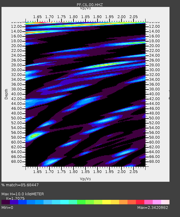
| Estimated Moho Depth: |
10.0 km |
| Estimated Crust Vp/Vs: |
1.71 |
| Assumed Crust Vp: |
4.73 km/s |
| Estimated Crust Vs: |
2.77 km/s |
| Estimated Crust Poisson's Ratio: |
0.24 |
|
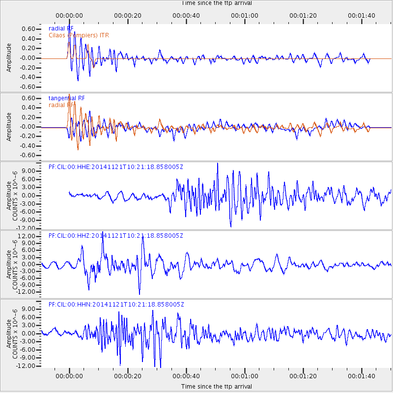
| Radial Match: |
85.68447 % |
| Radial Bump: |
400 |
| Transverse Match: |
56.474255 % |
| Transverse Bump: |
400 |
| SOD ConfigId: |
3390531 |
| Insert Time: |
2019-04-15 03:39:08.600 +0000 |
| GWidth: |
2.5 |
| Max Bumps: |
400 |
| Tol: |
0.001 |
|
Signal To Noise
| Channel | StoN | STA | LTA |
| PF:CIL:00:HHZ:20141121T10:21:18.858005Z | 4.989324 | 2.9976568E-6 | 6.008142E-7 |
| PF:CIL:00:HHN:20141121T10:21:18.858005Z | 0.57774293 | 1.1915491E-6 | 2.062421E-6 |
| PF:CIL:00:HHE:20141121T10:21:18.858005Z | 1.971542 | 1.8096885E-6 | 9.1790514E-7 |
| Arrivals |
| Ps | 1.5 SECOND |
| PpPs | 5.6 SECOND |
| PsPs/PpSs | 7.1 SECOND |


