You are here: Home > Network List > XJ13 - CRAFTI Stations List
> Station LL23 Sali PS > Earthquake Result Viewer
LL23 Sali PS - Earthquake Result Viewer
| Earthquake location: |
Northern Molucca Sea |
| Earthquake latitude/longitude: |
2.3/127.1 |
| Earthquake time(UTC): |
2014/11/21 (325) 10:10:19 GMT |
| Earthquake Depth: |
38 km |
| Earthquake Magnitude: |
6.5 MWC, 6.8 MI, 6.9 MI |
| Earthquake Catalog/Contributor: |
NEIC PDE/NEIC COMCAT |
|
| Network: |
XJ CRAFTI |
| Station: |
LL23 Sali PS |
| Lat/Lon: |
2.30 S/35.69 E |
| Elevation: |
1257 m |
|
| Distance: |
91.5 deg |
| Az: |
267.773 deg |
| Baz: |
87.794 deg |
| Ray Param: |
0.041595932 |
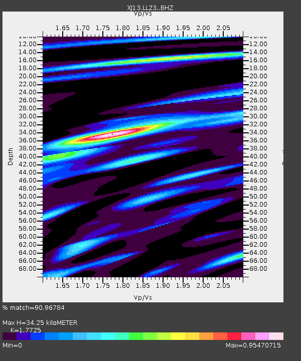
| Estimated Moho Depth: |
34.25 km |
| Estimated Crust Vp/Vs: |
1.77 |
| Assumed Crust Vp: |
6.576 km/s |
| Estimated Crust Vs: |
3.71 km/s |
| Estimated Crust Poisson's Ratio: |
0.27 |
|
| Radial Match: |
90.96784 % |
| Radial Bump: |
400 |
| Transverse Match: |
52.11657 % |
| Transverse Bump: |
400 |
| SOD ConfigId: |
3390531 |
| Insert Time: |
2019-04-15 03:40:12.397 +0000 |
| GWidth: |
2.5 |
| Max Bumps: |
400 |
| Tol: |
0.001 |
|

Signal To Noise
| Channel | StoN | STA | LTA |
| XJ:LL23: :BHZ:20141121T10:22:50.840Z | 6.777759 | 4.5954786E-7 | 6.780233E-8 |
| XJ:LL23: :BHN:20141121T10:22:50.840Z | 0.6647745 | 1.231242E-7 | 1.8521197E-7 |
| XJ:LL23: :BHE:20141121T10:22:50.840Z | 1.8093276 | 1.6246368E-7 | 8.9792294E-8 |
| Arrivals |
| Ps | 4.1 SECOND |
| PpPs | 14 SECOND |
| PsPs/PpSs | 18 SECOND |


