You are here: Home > Network List > TA - USArray Transportable Network (new EarthScope stations) Stations List
> Station W53A Cullowhee, NC, USA > Earthquake Result Viewer
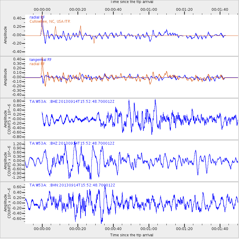
W53A Cullowhee, NC, USA - Earthquake Result Viewer
*The percent match for this event was below the threshold and hence no stack was calculated.
| Earthquake location: |
Andreanof Islands, Aleutian Is. |
| Earthquake latitude/longitude: |
51.4/-174.6 |
| Earthquake time(UTC): |
2013/09/14 (257) 15:42:46 GMT |
| Earthquake Depth: |
20 km |
| Earthquake Magnitude: |
5.9 MWW, 5.4 MI, 5.8 MWB, 5.9 MWC, 6.0 MWC |
| Earthquake Catalog/Contributor: |
NEIC PDE/NEIC COMCAT |
|
| Network: |
TA USArray Transportable Network (new EarthScope stations) |
| Station: |
W53A Cullowhee, NC, USA |
| Lat/Lon: |
35.17 N/83.16 W |
| Elevation: |
1180 m |
|
| Distance: |
64.3 deg |
| Az: |
65.379 deg |
| Baz: |
316.011 deg |
| Ray Param: |
$rayparam |
*The percent match for this event was below the threshold and hence was not used in the summary stack. |
|
| Radial Match: |
69.77361 % |
| Radial Bump: |
400 |
| Transverse Match: |
56.429092 % |
| Transverse Bump: |
400 |
| SOD ConfigId: |
626651 |
| Insert Time: |
2014-04-18 16:41:22.650 +0000 |
| GWidth: |
2.5 |
| Max Bumps: |
400 |
| Tol: |
0.001 |
|
Signal To Noise
| Channel | StoN | STA | LTA |
| TA:W53A: :BHZ:20130914T15:52:48.700012Z | 2.4869742 | 5.671096E-7 | 2.2803195E-7 |
| TA:W53A: :BHN:20130914T15:52:48.700012Z | 1.4490439 | 2.0327339E-7 | 1.4028103E-7 |
| TA:W53A: :BHE:20130914T15:52:48.700012Z | 1.4476304 | 1.7131613E-7 | 1.18342456E-7 |
| Arrivals |
| Ps | |
| PpPs | |
| PsPs/PpSs | |


