You are here: Home > Network List > XJ13 - CRAFTI Stations List
> Station LN34 Lwondulwo boma > Earthquake Result Viewer
LN34 Lwondulwo boma - Earthquake Result Viewer
| Earthquake location: |
Northern Molucca Sea |
| Earthquake latitude/longitude: |
2.3/127.1 |
| Earthquake time(UTC): |
2014/11/21 (325) 10:10:19 GMT |
| Earthquake Depth: |
38 km |
| Earthquake Magnitude: |
6.5 MWC, 6.8 MI, 6.9 MI |
| Earthquake Catalog/Contributor: |
NEIC PDE/NEIC COMCAT |
|
| Network: |
XJ CRAFTI |
| Station: |
LN34 Lwondulwo boma |
| Lat/Lon: |
2.75 S/36.05 E |
| Elevation: |
1066 m |
|
| Distance: |
91.1 deg |
| Az: |
267.309 deg |
| Baz: |
87.789 deg |
| Ray Param: |
0.041620214 |
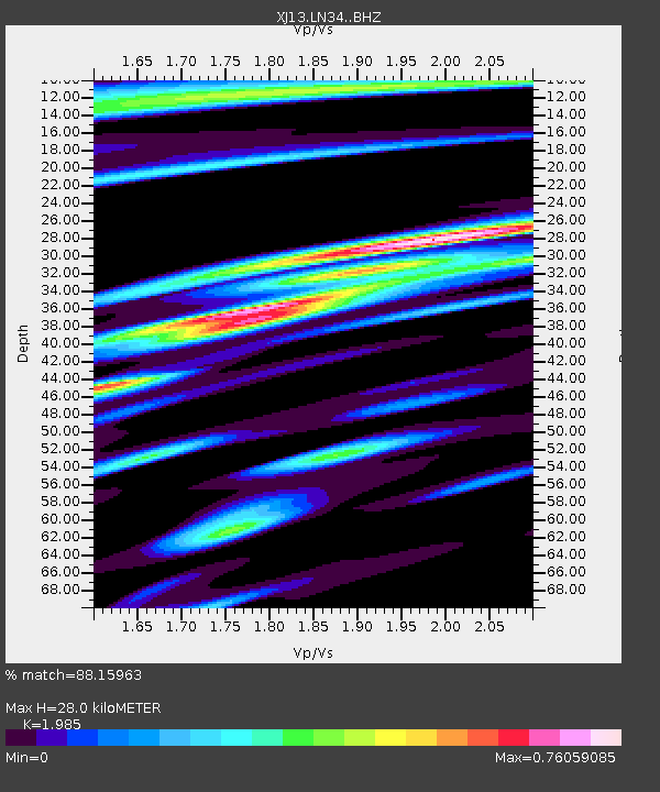
| Estimated Moho Depth: |
28.0 km |
| Estimated Crust Vp/Vs: |
1.99 |
| Assumed Crust Vp: |
6.601 km/s |
| Estimated Crust Vs: |
3.325 km/s |
| Estimated Crust Poisson's Ratio: |
0.33 |
|
| Radial Match: |
88.15963 % |
| Radial Bump: |
400 |
| Transverse Match: |
77.30029 % |
| Transverse Bump: |
400 |
| SOD ConfigId: |
3390531 |
| Insert Time: |
2019-04-15 03:40:17.003 +0000 |
| GWidth: |
2.5 |
| Max Bumps: |
400 |
| Tol: |
0.001 |
|

Signal To Noise
| Channel | StoN | STA | LTA |
| XJ:LN34: :BHZ:20141121T10:22:49.259983Z | 8.133682 | 4.746045E-7 | 5.835051E-8 |
| XJ:LN34: :BHN:20141121T10:22:49.259983Z | 1.2868152 | 7.472376E-8 | 5.8068757E-8 |
| XJ:LN34: :BHE:20141121T10:22:49.259983Z | 1.7320553 | 1.4477477E-7 | 8.358554E-8 |
| Arrivals |
| Ps | 4.3 SECOND |
| PpPs | 12 SECOND |
| PsPs/PpSs | 17 SECOND |


