You are here: Home > Network List > XJ13 - CRAFTI Stations List
> Station NG54 Nasera Bomas > Earthquake Result Viewer
NG54 Nasera Bomas - Earthquake Result Viewer
| Earthquake location: |
Northern Molucca Sea |
| Earthquake latitude/longitude: |
2.3/127.1 |
| Earthquake time(UTC): |
2014/11/21 (325) 10:10:19 GMT |
| Earthquake Depth: |
38 km |
| Earthquake Magnitude: |
6.5 MWC, 6.8 MI, 6.9 MI |
| Earthquake Catalog/Contributor: |
NEIC PDE/NEIC COMCAT |
|
| Network: |
XJ CRAFTI |
| Station: |
NG54 Nasera Bomas |
| Lat/Lon: |
2.73 S/35.36 E |
| Elevation: |
1853 m |
|
| Distance: |
91.8 deg |
| Az: |
267.354 deg |
| Baz: |
87.82 deg |
| Ray Param: |
0.041544244 |
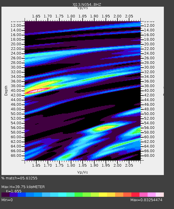
| Estimated Moho Depth: |
39.75 km |
| Estimated Crust Vp/Vs: |
1.65 |
| Assumed Crust Vp: |
6.576 km/s |
| Estimated Crust Vs: |
3.974 km/s |
| Estimated Crust Poisson's Ratio: |
0.21 |
|
| Radial Match: |
85.63255 % |
| Radial Bump: |
400 |
| Transverse Match: |
72.94951 % |
| Transverse Bump: |
400 |
| SOD ConfigId: |
3390531 |
| Insert Time: |
2019-04-15 03:40:19.929 +0000 |
| GWidth: |
2.5 |
| Max Bumps: |
400 |
| Tol: |
0.001 |
|

Signal To Noise
| Channel | StoN | STA | LTA |
| XJ:NG54: :BHZ:20141121T10:22:52.439976Z | 5.1166573 | 4.1873375E-7 | 8.183737E-8 |
| XJ:NG54: :BHN:20141121T10:22:52.439976Z | 0.5748341 | 9.1311506E-8 | 1.5884845E-7 |
| XJ:NG54: :BHE:20141121T10:22:52.439976Z | 1.1263705 | 1.9745495E-7 | 1.7530195E-7 |
| Arrivals |
| Ps | 4.1 SECOND |
| PpPs | 16 SECOND |
| PsPs/PpSs | 20 SECOND |


