You are here: Home > Network List > XJ13 - CRAFTI Stations List
> Station PR61 Kiloki Boma > Earthquake Result Viewer
PR61 Kiloki Boma - Earthquake Result Viewer
| Earthquake location: |
Northern Molucca Sea |
| Earthquake latitude/longitude: |
2.3/127.1 |
| Earthquake time(UTC): |
2014/11/21 (325) 10:10:19 GMT |
| Earthquake Depth: |
38 km |
| Earthquake Magnitude: |
6.5 MWC, 6.8 MI, 6.9 MI |
| Earthquake Catalog/Contributor: |
NEIC PDE/NEIC COMCAT |
|
| Network: |
XJ CRAFTI |
| Station: |
PR61 Kiloki Boma |
| Lat/Lon: |
2.96 S/35.25 E |
| Elevation: |
1549 m |
|
| Distance: |
91.9 deg |
| Az: |
267.133 deg |
| Baz: |
87.833 deg |
| Ray Param: |
0.04152605 |
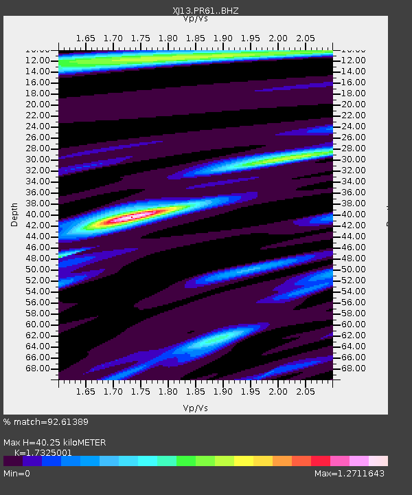
| Estimated Moho Depth: |
40.25 km |
| Estimated Crust Vp/Vs: |
1.73 |
| Assumed Crust Vp: |
6.576 km/s |
| Estimated Crust Vs: |
3.796 km/s |
| Estimated Crust Poisson's Ratio: |
0.25 |
|
| Radial Match: |
92.61389 % |
| Radial Bump: |
400 |
| Transverse Match: |
78.9367 % |
| Transverse Bump: |
400 |
| SOD ConfigId: |
3390531 |
| Insert Time: |
2019-04-15 03:40:22.771 +0000 |
| GWidth: |
2.5 |
| Max Bumps: |
400 |
| Tol: |
0.001 |
|

Signal To Noise
| Channel | StoN | STA | LTA |
| XJ:PR61: :BHZ:20141121T10:22:52.980015Z | 5.73019 | 3.8112938E-7 | 6.651252E-8 |
| XJ:PR61: :BHN:20141121T10:22:52.980015Z | 0.4123661 | 3.546335E-8 | 8.599968E-8 |
| XJ:PR61: :BHE:20141121T10:22:52.980015Z | 2.4873393 | 2.1339949E-7 | 8.5794284E-8 |
| Arrivals |
| Ps | 4.6 SECOND |
| PpPs | 16 SECOND |
| PsPs/PpSs | 21 SECOND |


