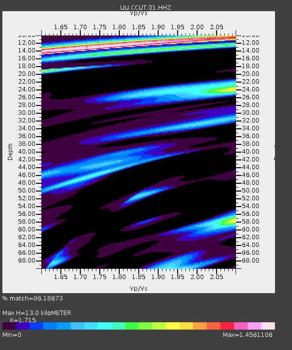
CCUT Cedar City, UT, USA - Earthquake Result Viewer
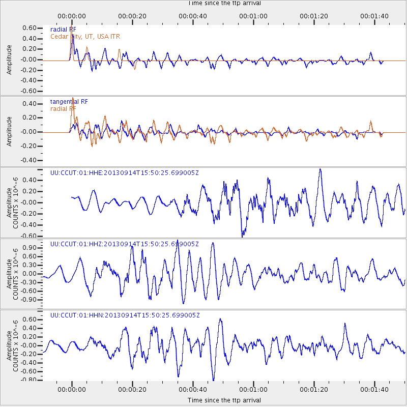
Earthquake location: Andreanof Islands, Aleutian Is.
Earthquake latitude/longitude: 51.4/-174.6
Earthquake time(UTC): 2013/09/14 (257) 15:42:46 GMT
Earthquake Depth: 20 km
Earthquake Magnitude: 5.9 MWW, 5.4 MI, 5.8 MWB, 5.9 MWC, 6.0 MWC
Earthquake Catalog/Contributor: NEIC PDE/NEIC COMCAT
Network: UU University of Utah Regional Network
Station: CCUT Cedar City, UT, USA
Lat/Lon: 37.55 N/113.36 W
Elevation: 2127 m
Distance: 44.6 deg
Az: 83.295 deg
Baz: 308.544 deg
Ray Param: 0.0718103
Estimated Moho Depth: 13.0 km
Estimated Crust Vp/Vs: 1.72
Assumed Crust Vp: 6.194 km/s
Estimated Crust Vs: 3.612 km/s
Estimated Crust Poisson's Ratio: 0.24
Radial Match: 86.18673 %
Radial Bump: 400
Transverse Match: 74.90856 %
Transverse Bump: 400
SOD ConfigId: 626651
Insert Time: 2014-04-18 16:46:47.761 +0000
GWidth: 2.5
Max Bumps: 400
Tol: 0.001

Signal To Noise

ChannelStoNSTALTA
UU:CCUT:01:HHZ:20130914T15:50:25.699005Z3.473663.0806336E-78.8685525E-8
UU:CCUT:01:HHN:20130914T15:50:25.699005Z0.874989457.2968085E-88.3393104E-8
UU:CCUT:01:HHE:20130914T15:50:25.699005Z0.52720334.541865E-88.615016E-8
Arrivals
Ps1.6 SECOND
PpPs5.4 SECOND
PsPs/PpSs7.0 SECOND