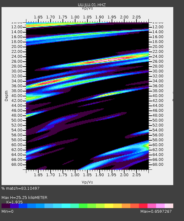
JLU Jordanelle, UT, USA - Earthquake Result Viewer

Earthquake location: Andreanof Islands, Aleutian Is.
Earthquake latitude/longitude: 51.4/-174.6
Earthquake time(UTC): 2013/09/14 (257) 15:42:46 GMT
Earthquake Depth: 20 km
Earthquake Magnitude: 5.9 MWW, 5.4 MI, 5.8 MWB, 5.9 MWC, 6.0 MWC
Earthquake Catalog/Contributor: NEIC PDE/NEIC COMCAT
Network: UU University of Utah Regional Network
Station: JLU Jordanelle, UT, USA
Lat/Lon: 40.60 N/111.45 W
Elevation: 2285 m
Distance: 43.9 deg
Az: 78.529 deg
Baz: 306.33 deg
Ray Param: 0.072224826
Estimated Moho Depth: 25.25 km
Estimated Crust Vp/Vs: 1.93
Assumed Crust Vp: 6.155 km/s
Estimated Crust Vs: 3.181 km/s
Estimated Crust Poisson's Ratio: 0.32
Radial Match: 83.10497 %
Radial Bump: 400
Transverse Match: 81.21811 %
Transverse Bump: 400
SOD ConfigId: 626651
Insert Time: 2014-04-18 16:47:05.645 +0000
GWidth: 2.5
Max Bumps: 400
Tol: 0.001

Signal To Noise

ChannelStoNSTALTA
UU:JLU:01:HHZ:20130914T15:50:20.338989Z5.98273231.1030369E-81.8437007E-9
UU:JLU:01:HHN:20130914T15:50:20.338989Z2.1198664.264507E-92.0116873E-9
UU:JLU:01:HHE:20130914T15:50:20.338989Z1.75965753.6454375E-92.0716744E-9
Arrivals
Ps4.1 SECOND
PpPs11 SECOND
PsPs/PpSs15 SECOND