You are here: Home > Network List > IU - Global Seismograph Network (GSN - IRIS/USGS) Stations List
> Station PMG Port Moresby, New Guinea > Earthquake Result Viewer
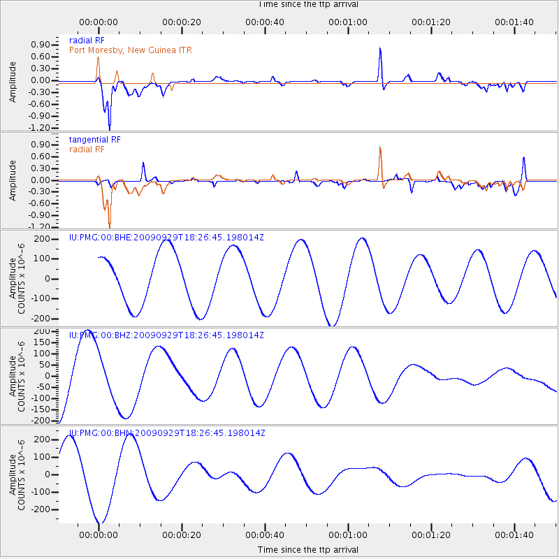
PMG Port Moresby, New Guinea - Earthquake Result Viewer
*The percent match for this event was below the threshold and hence no stack was calculated.
| Earthquake location: |
Samoa Islands Region |
| Earthquake latitude/longitude: |
-15.9/-171.7 |
| Earthquake time(UTC): |
2009/09/29 (272) 18:19:35 GMT |
| Earthquake Depth: |
10 km |
| Earthquake Magnitude: |
5.6 MB |
| Earthquake Catalog/Contributor: |
WHDF/NEIC |
|
| Network: |
IU Global Seismograph Network (GSN - IRIS/USGS) |
| Station: |
PMG Port Moresby, New Guinea |
| Lat/Lon: |
9.40 S/147.16 E |
| Elevation: |
90 m |
|
| Distance: |
40.6 deg |
| Az: |
274.097 deg |
| Baz: |
103.475 deg |
| Ray Param: |
$rayparam |
*The percent match for this event was below the threshold and hence was not used in the summary stack. |
|
| Radial Match: |
70.05905 % |
| Radial Bump: |
398 |
| Transverse Match: |
32.28455 % |
| Transverse Bump: |
386 |
| SOD ConfigId: |
1 |
| Insert Time: |
2010-02-19 00:22:14.381 +0000 |
| GWidth: |
2.5 |
| Max Bumps: |
400 |
| Tol: |
0.001 |
|
Signal To Noise
| Channel | StoN | STA | LTA |
| IU:PMG:00:BHZ:20090929T18:26:45.198014Z | 1.1732763 | 1.0489743E-4 | 8.940557E-5 |
| IU:PMG:00:BHN:20090929T18:26:45.198014Z | 1.6067832 | 2.1372615E-4 | 1.3301492E-4 |
| IU:PMG:00:BHE:20090929T18:26:45.198014Z | 1.1076941 | 1.43842E-4 | 1.2985716E-4 |
| Arrivals |
| Ps | |
| PpPs | |
| PsPs/PpSs | |


